

Four U.S. states border Mexico: California, Arizona, New Mexico, and Texas. From west to east, their shared international boundary runs from the Pacific Ocean to the Gulf of Mexico and measures 1,954 miles under the current International Boundary and Water Commission (IBWC) continental-boundary framework.
The border is not one continuous straight land line. California and New Mexico have monumented land sections, Arizona combines a monumented land section with a 24-mile Colorado River boundary, and Texas follows the Rio Grande, or Río Bravo del Norte, for about 1,255 miles. Six Mexican states lie on the opposite side of the boundary.
Which States Border Mexico?
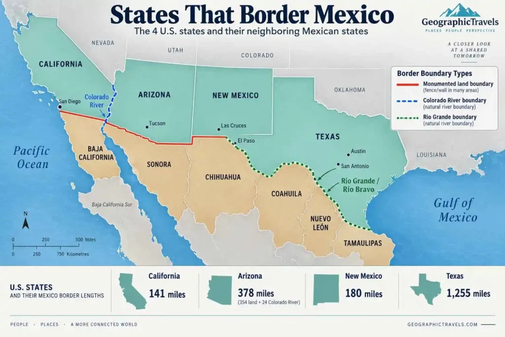
The four U.S. states are arranged below from west to east.
| U.S. State | Mexican State(s) | Approx. Border Length | Boundary Type |
|---|---|---|---|
| California | Baja California | 141 miles | Monumented land boundary |
| Arizona | Baja California, Sonora | 378 miles total | 354 miles land + 24 miles Colorado River |
| New Mexico | Chihuahua | 180 miles | Monumented land boundary |
| Texas | Chihuahua, Coahuila, Nuevo León, Tamaulipas | 1,255 miles | Rio Grande / Río Bravo |
Measurement note: These figures follow the current IBWC boundary framework. The agency’s official map separates Arizona’s 354-mile land section from its 24-mile Colorado River section. Adding the four state totals gives the IBWC’s 1,954-mile continental boundary. Separate maritime boundaries in the Pacific and Gulf of Mexico are not included.
Arizona deserves special attention. Its total is 378 miles, not 354 miles, when the Colorado River section is included. That 24-mile international river segment places Arizona directly opposite Baja California; the longer monumented land section lies opposite Sonora. New Mexico’s measurable Mexico boundary is with Chihuahua.
The Four U.S. States That Border Mexico
1. California
California forms the western end of the U.S.–Mexico continental boundary. Its approximately 141-mile international section runs from the Pacific Ocean eastward to the Colorado River area and lies opposite Baja California.
The western end is the heavily urbanized San Diego–Tijuana region. Farther east, the border crosses drier inland terrain, including the Imperial Valley region. Calexico and Mexicali form another clear cross-border urban pair.
California has the shortest Mexico boundary of the four U.S. states under the current IBWC measurement framework. Unlike Arizona and Texas, its international section is classified in the IBWC breakdown as a monumented land boundary rather than a river boundary.
2. Arizona
Arizona’s international boundary is more geographically varied than a simple straight line suggests.
The IBWC separates it into 354 miles of monumented land boundary and 24 miles along the Colorado River, for a combined total of about 378 miles. The land portion is opposite Sonora, while the international Colorado River segment separates Arizona from Baja California.
This distinction is easy to miss because many simplified maps treat Arizona as bordering only Sonora or list only the land section. The Colorado River segment is part of Arizona’s international boundary and belongs in a state total when the same IBWC framework is used for all four states.
Much of southern Arizona lies within the Sonoran Desert and mountain-and-basin landscapes. Nogales, Arizona, and Nogales, Sonora, form one of the clearest paired border communities. Douglas and Agua Prieta are another.
3. New Mexico
New Mexico shares approximately 180 miles of international boundary with Chihuahua.
Its border is primarily a monumented land line across the Chihuahuan Desert region. The line extends from the Arizona state boundary eastward to the El Paso area, where the international boundary reaches the Rio Grande.
The distinction at the eastern end matters. The Rio Grande flows through New Mexico, but it does not form the New Mexico–Mexico international boundary. The long river-defined international section begins farther downstream at the El Paso–Ciudad Juárez area and belongs to the Texas portion of the boundary.
Columbus, New Mexico, and Puerto Palomas, Chihuahua, are a useful pair for locating the state’s border on a map. Santa Teresa is another important border community near the El Paso metropolitan region.
4. Texas
Texas has by far the longest U.S. state boundary with Mexico: approximately 1,255 miles under the IBWC framework.
Unlike the monumented land sections farther west, the Texas boundary follows the Rio Grande, known in Mexico as the Río Bravo or Río Bravo del Norte. The two names refer to the same river.
Texas borders four Mexican states: Chihuahua, Coahuila, Nuevo León, and Tamaulipas. No other U.S. state borders as many Mexican states.
The river boundary begins in the El Paso–Ciudad Juárez area and continues southeast and then east toward the Gulf of Mexico. Along the way are several major neighboring urban areas, including Del Rio–Ciudad Acuña, Eagle Pass–Piedras Negras, Laredo–Nuevo Laredo, and Brownsville–Matamoros.
Because the boundary follows a river, its geography is fundamentally different from a straight surveyed line. River movement has historically created boundary questions, which is one reason later U.S.–Mexico agreements established procedures for maintaining the Rio Grande as the international boundary.
Which State Has the Longest Border With Mexico?
Texas has the longest U.S. state border with Mexico, at approximately 1,255 miles.
That is nearly two-thirds of the entire 1,954-mile continental boundary by itself. The length reflects the winding course of the Rio Grande from the El Paso–Ciudad Juárez area to the Gulf of Mexico.
Using the same IBWC framework, the four states rank by border length as:
- Texas — 1,255 miles
- Arizona — 378 miles, including the Colorado River section
- New Mexico — 180 miles
- California — 141 miles
Which State Has the Shortest Border With Mexico?
California has the shortest Mexico boundary of the four U.S. states, at approximately 141 miles.
New Mexico is next at about 180 miles. Arizona’s full state total is longer because its approximately 354-mile monumented land boundary is supplemented by the 24-mile Colorado River section.
Using one IBWC framework is important here. Older federal and secondary sources sometimes publish slightly different figures, especially for Texas and Arizona. Those values should not be mixed into one ranking as though they were measured under identical conventions.
Which Mexican States Border the United States?
Six Mexican states form the Mexican side of the continental boundary.
| Mexican State | U.S. State(s) It Borders | General Border Section |
|---|---|---|
| Baja California | California, Arizona | Pacific end and Colorado River section |
| Sonora | Arizona | Western inland / Sonoran Desert section |
| Chihuahua | New Mexico, Texas | Chihuahuan Desert and upper Rio Grande section |
| Coahuila | Texas | Rio Grande |
| Nuevo León | Texas | Short Rio Grande section |
| Tamaulipas | Texas | Lower Rio Grande to the Gulf |
The numbers are not symmetrical: four U.S. states face six Mexican states. Texas alone borders four Mexican states, while Arizona’s international boundary includes both Sonora and a 24-mile Colorado River section opposite Baja California.
A point where several state boundaries meet should not be treated as a measurable shared border unless an actual boundary segment exists. Under the IBWC framework used here, New Mexico’s international section is paired with Chihuahua rather than Sonora.
How Long Is the U.S.–Mexico Border?
The U.S.–Mexico continental boundary is 1,954 miles long under the current IBWC framework.
Its main components are:
- 675 miles of monumented land boundary across California, Arizona, and New Mexico
- 24 miles along the Colorado River
- 1,255 miles along the Rio Grande
- 1,954 miles total
The continental figure excludes separate maritime boundaries. It also should not be confused with the length of border fencing, walls, roads, ports of entry, or other infrastructure. The international boundary exists continuously whether or not a physical barrier stands at a particular location.
A second distinction is the border region. Under the 1983 La Paz Agreement, environmental programs have defined a broader U.S.–Mexico border region extending 100 kilometers, about 62 miles, on each side of the international line. That is an administrative region around the boundary, not the boundary itself.
How Much of the U.S.–Mexico Border Follows Rivers?
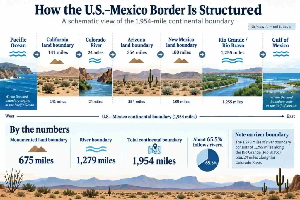
About 1,279 miles of the 1,954-mile continental boundary follow rivers under the IBWC segment framework:
- Rio Grande: 1,255 miles
- Colorado River: 24 miles
Together, that is about 65.5% of the continental boundary, a calculation from the IBWC segment figures. The remaining 675 miles are monumented land boundary.
This is why describing the entire U.S.–Mexico border as a straight desert land line is inaccurate. Most of its measured length is river-defined, even though the western land sections are visually prominent on maps.
What Does the U.S.–Mexico Border Look Like Geographically?
The boundary crosses several very different physical landscapes from west to east.
At the Pacific end, the line begins in a coastal environment near the San Diego–Tijuana urban region. Moving inland, it reaches increasingly dry terrain and the lower Colorado River region.
Across Arizona, the boundary crosses the Sonoran Desert and mountain-and-basin country. Farther east, southern New Mexico and west Texas enter the Chihuahuan Desert, where broad basins alternate with mountain ranges.
Texas then changes the pattern. The international line follows the Rio Grande through desert canyon country, river valleys, southern Texas plains, and eventually the low-relief Gulf Coastal Plain. USGS borderlands research identifies several distinct ecoregions along the full border, reinforcing that the boundary is not geographically uniform.
A simplified west-to-east sequence is:
Pacific Ocean → California land boundary → Colorado River → Arizona land boundary → New Mexico land boundary → El Paso–Ciudad Juárez → Rio Grande / Río Bravo → Gulf of Mexico
That sequence is useful for orientation, but it is a schematic rather than a scale-accurate representation.
Major Cities Along the U.S.–Mexico Border
The border contains several neighboring urban areas that make the state-to-state relationships easier to visualize.
| U.S. City | Mexican Counterpart | State Pair |
|---|---|---|
| San Diego | Tijuana | California — Baja California |
| Calexico | Mexicali | California — Baja California |
| Nogales | Nogales | Arizona — Sonora |
| Douglas | Agua Prieta | Arizona — Sonora |
| Columbus | Puerto Palomas | New Mexico — Chihuahua |
| El Paso | Ciudad Juárez | Texas — Chihuahua |
| Del Rio | Ciudad Acuña | Texas — Coahuila |
| Eagle Pass | Piedras Negras | Texas — Coahuila |
| Laredo | Nuevo Laredo | Texas — Tamaulipas |
| Brownsville | Matamoros | Texas — Tamaulipas |
These examples are geographical pairs, not an exhaustive list of ports of entry. A port of entry is an authorized crossing facility; it is not itself a segment of the international boundary.
How Was the Modern U.S.–Mexico Border Established?
The modern boundary developed through several treaties rather than one single survey.
The Treaty of Guadalupe Hidalgo, signed in 1848, ended the Mexican–American War. The National Archives’ treaty record explains that Mexico relinquished claims to Texas and recognized the Rio Grande as the southern boundary of the United States while establishing a western boundary toward the Pacific.
The line across what is now southern Arizona and New Mexico was adjusted several years later by the Gadsden Purchase, negotiated in 1853 and finalized in 1854. The U.S. Office of the Historian describes the purchase as adding 29,670 square miles to the United States and helping establish the present southern boundary in that region.
Later agreements dealt with surveying, monuments, and river movement. The 1970 Boundary Treaty resolved remaining boundary differences and established procedures for maintaining the Rio Grande and Colorado River as the international boundary when river channels change.
The result is the boundary visible today: a combination of monumented surveyed lines and river-defined sections rather than one uniform type of border.
U.S.–Mexico Border vs U.S.–Canada Border
The southern international boundary is concentrated in just four U.S. states. By contrast, 13 states that border Canada share the country’s northern international boundary.
The geographic structures are also different. The Mexico boundary is dominated by the Rio Grande and long monumented desert sections, plus the short Colorado River segment. The Canada boundary includes long surveyed lines as well as extensive boundaries through the Great Lakes, the St. Lawrence system, rivers, and other waters.
The comparison is useful because it shows why “border state” does not necessarily mean a state has a dry-land boundary. International boundaries can run through rivers and lakes just as legitimately as across land.
The Bottom Line
Four U.S. states border Mexico: California, Arizona, New Mexico, and Texas. Six Mexican states lie on the opposite side: Baja California, Sonora, Chihuahua, Coahuila, Nuevo León, and Tamaulipas.
Texas has the longest state section at about 1,255 miles, while California has the shortest at about 141 miles. The boundary is geographically mixed: 675 miles are monumented land sections, 24 miles follow the Colorado River, and 1,255 miles follow the Rio Grande.
Understanding those different boundary types makes the map much clearer. The U.S.–Mexico border is not simply a straight line through desert terrain; it is a Pacific-to-Gulf international boundary shaped by surveyed lines, two major rivers, mountains, deserts, plains, and neighboring cities.
Frequently Asked Questions
Four U.S. states border Mexico: California, Arizona, New Mexico, and Texas. In west-to-east order, they extend from the Pacific Ocean to the Gulf of Mexico.
The four states are California, Arizona, New Mexico, and Texas. California has the shortest section, while Texas has by far the longest.
Texas has the longest border with Mexico at approximately 1,255 miles under the current IBWC framework. Its international boundary follows the Rio Grande from the El Paso–Ciudad Juárez area to the Gulf of Mexico.
California has the shortest of the four state boundaries at approximately 141 miles. Its boundary with Baja California extends from the Pacific Ocean eastward to the Colorado River area.
Texas borders Chihuahua, Coahuila, Nuevo León, and Tamaulipas. All four relationships occur along the Rio Grande / Río Bravo boundary.
Yes. Arizona has a 24-mile international boundary along the Colorado River where the opposite bank is in Baja California. Arizona’s much longer monumented land boundary lies opposite Sonora.
No. The Rio Grande forms about 1,255 miles of the boundary along Texas. The border also includes 675 miles of monumented land boundary across California, Arizona and New Mexico, plus a 24-mile Colorado River section.
The IBWC gives the continental U.S.–Mexico boundary as approximately 1,954 miles. That figure excludes separate maritime boundary segments in the Pacific Ocean and Gulf of Mexico.

