


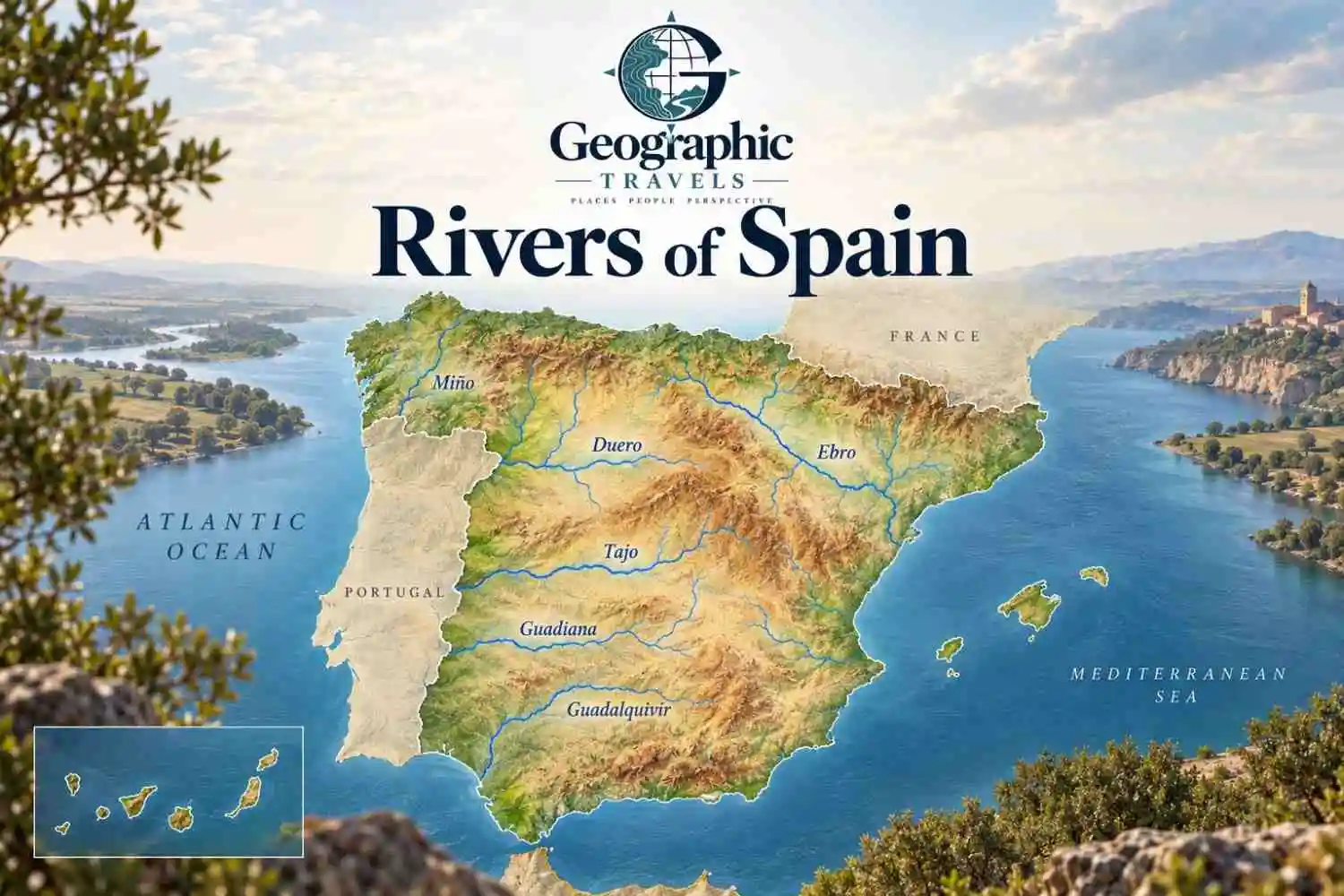
Spain’s major rivers include the Tajo (Tagus), Ebro, Duero, Guadiana, Guadalquivir, Miño, Júcar, and Segura. The Tajo is the longest river of the Iberian Peninsula when its full Spanish-Portuguese course is counted, while the Ebro is the longest river whose entire course lies within Spain. Most of Spain’s great interior rivers drain west toward the Atlantic, but the Ebro breaks that pattern and flows east to the Mediterranean.
Spain’s rivers also sit within the wider river geography of Europe, but the country’s own drainage pattern is unusually easy to read once you look at the Meseta Central, the mountain ranges around it, and the three broad drainage directions: Cantabrian, Atlantic, and Mediterranean.
Major Rivers of Spain at a Glance
The table separates total river length from the part of a river associated with Spanish territory. That matters because the Tajo, Duero, Miño, and Guadiana are international rivers.
| River | Approx. Total Length | Course in Spain | Main Drainage | Major Place | Final Outlet | Key Qualification |
|---|---|---|---|---|---|---|
| Tajo / Tagus | about 1,130 km | about 857 km in Spain + 43 km on the border | Atlantic | Toledo | Tagus estuary at Lisbon | Longest river of the Iberian Peninsula under the bilateral convention used here |
| Ebro | about 910.5 km | Entirely in Spain | Mediterranean | Zaragoza | Ebro Delta | Longest river entirely within Spain |
| Duero / Douro | about 927 km | 597 km in Spain + 122 km on the border | Atlantic | Zamora | Atlantic at Porto | Continues through Portugal as the Douro |
| Guadiana | about 818 km | International river with Spanish and border reaches | Atlantic | Badajoz | Gulf of Cádiz / Atlantic | Headwater definitions require care |
| Guadalquivir | 657 km | Entirely in Spain | Atlantic | Córdoba, Seville | Gulf of Cádiz | Major river of Andalusia |
| Miño / Minho | 315 km | Mainly Spain; lower course forms the border | Atlantic | Galicia | Atlantic between Spain and Portugal | Major Galician river with important Sil tributary |
| Júcar / Xúquer | about 508 km | Entirely in Spain | Mediterranean | Eastern Spain | Mediterranean near Cullera | Independent Mediterranean river |
| Segura | 325 km | Entirely in Spain | Mediterranean | Murcia | Mediterranean near Guardamar | Major southeastern river |
Source and method note: Spain’s Instituto Geográfico Nacional identifies principal rivers, national sections, border sections, receiving rivers, sources, and mouths. For internationally shared rivers, this guide uses the more specific current basin or bilateral authority where available instead of averaging conflicting published figures.
What Is the Longest River in Spain?
Here’s where the answer needs a definition.
Tajo: Longest River of the Iberian Peninsula
The Tajo, called the Tejo in Portugal and Tagus in English, is the longest river of the Iberian Peninsula under the current bilateral description used here.
The Albufeira Convention commission gives the Tajo a total length of about 1,130 km, with about 857 km in Spanish territory and 43 km forming part of the Spain–Portugal boundary. It then continues across Portugal and reaches the Atlantic through the Tagus estuary at Lisbon.
You will also encounter lower values such as 1,007 or 1,038 km on widely cited pages. Those differences reflect different river-length datasets and measurement conventions. This article does not average them.
Ebro: Longest River Entirely Within Spain
The Ebro is the longest river whose complete course lies within Spain.
The Ebro authority describes a main channel of about 910.5 km. The river flows from northern Spain through the Ebro Depression, passes Zaragoza, cuts through the Catalan coastal ranges, and reaches the Mediterranean through the Ebro Delta.
Which River Has the Longest Course Inside Spain?
Using the official values adopted here, the Ebro also has the longest continuous course entirely within Spanish territory at about 910.5 km.
The Tajo has about 857 km entirely in Spain plus roughly 43 km along the international boundary. Even if that border section is included in a Spain-associated measurement, the total remains slightly shorter than the Ebro’s fully Spanish course.
So the apparently contradictory answers are both useful:
- Longest river of the Iberian Peninsula: Tajo / Tagus
- Longest river entirely within Spain: Ebro
- Longest course wholly inside Spanish territory: Ebro
How Spain’s River Map Actually Works
Look at Spain’s river map and a pattern appears quickly.
The Meseta Central occupies much of the interior. Mountain systems frame and divide that high plateau: the Sistema Ibérico rises toward the east, the Sistema Central divides parts of the interior, the Montes de Toledo interrupt the southern Meseta, and Sierra Morena separates the plateau from the Guadalquivir depression.
Because the broad interior tilts mainly toward the west and southwest, several of the largest rivers follow that direction toward Portugal and the Atlantic.
The Ebro occupies a different structural setting. Its drainage basin lies in a long depression between the Pyrenees and the Sistema Ibérico, opening eastward toward the Mediterranean.
Spain therefore makes more sense as three drainage directions than as one list of famous rivers.
Spain’s Three Main Drainage Slopes
Cantabrian Drainage
Northern Spain has many short rivers that descend quickly from mountains close to the coast.
Representative systems include the Nalón, Navia, Sella, Nervión–Ibaizabal, and Bidasoa. These rivers generally have shorter source-to-sea distances, steeper gradients, smaller drainage basins, and more reliable rainfall than many interior Spanish rivers.
That does not mean every Cantabrian river behaves identically, but the contrast with the Meseta’s long west-flowing rivers is striking.
Atlantic Drainage
The Atlantic side contains most of Spain’s great interior systems:
- Miño
- Duero
- Tajo
- Guadiana
- Guadalquivir
The Duero and Tajo cross from Spain into Portugal. The Miño and Guadiana form international boundary sections. The Guadalquivir remains in Spain before reaching the Gulf of Cádiz.
These rivers collectively drain much of the western half of peninsular Spain.
Mediterranean Drainage
The Mediterranean side includes the Ebro, Júcar, Segura, Turia, Llobregat, and Ter, among many smaller coastal systems.
The Ebro is the great exception to the idea that Mediterranean rivers are necessarily short. Its large interior basin and long depression allow it to develop a course comparable with Spain’s major Atlantic rivers.
Catalonia also contains important internal river systems such as the Llobregat and Ter that do not simply belong to the Ebro basin.
Major Atlantic Rivers of Spain
Miño / Minho
The Miño rises in Galicia and flows about 315 km before reaching the Atlantic. The lower river forms part of the Spain–Portugal boundary, where Portuguese usage calls it the Minho.
The Sil is its largest important tributary in the Spanish basin. The Miño-Sil system illustrates how a river’s main name and its largest tributary can tell different parts of the hydrological story.
Duero / Douro
The Duero rises in the Picos de Urbión area and drains much of the northern Meseta.
Current Duero basin material gives a total source-to-mouth length of about 927 km: 597 km in Spain, 122 km forming the international boundary, and 208 km in Portugal.
In Portugal, the river becomes the Douro and reaches the Atlantic at Porto.
Major tributaries include the Esla and Pisuerga from the north and the Tormes and Águeda from the south.
Tajo / Tagus
The Tajo rises in the Montes Universales and crosses central Spain toward the west.
Toledo stands directly on the main river. Madrid does not.
The river’s major Spanish tributaries include the Jarama, Alberche, Tiétar, and Alagón. After reaching the Portuguese border and then Portugal itself, the river continues as the Tejo toward Lisbon.
The Tajo is a perfect example of why total international length should not be presented as though every kilometer lies within Spain.
Guadiana
The Guadiana crosses the southern Meseta, passes Badajoz, turns south, and eventually reaches the Gulf of Cádiz between Spain and Portugal.
Its headwater geography is unusually complicated. Traditional descriptions often say the river disappears underground and later “reappears” at the Ojos del Guadiana. Modern hydrogeology gives a more precise picture.
The Geological and Mining Institute of Spain explains the Ojos del Guadiana as groundwater springs produced where the water table intersects the land surface. The Guadiana Alto above them can lose surface water by infiltration, while the Ojos reflect groundwater discharge from the Mancha Occidental aquifer system.
That is more accurate than imagining one continuous underground river traveling invisibly from the Lagunas de Ruidera to the Ojos.
Guadalquivir
The Guadalquivir is about 657 km long and forms the main river axis of Andalusia.
It rises in the Cazorla area, crosses the Guadalquivir depression, flows through Córdoba and Seville, and reaches the Atlantic through the Gulf of Cádiz.
The Genil is one of its major tributaries. The broad lower valley and marshlands differ sharply from the steep northern rivers of the Cantabrian slope.
Major Mediterranean Rivers of Spain
Ebro
The Ebro is Spain’s longest fully domestic river and the central river of northeastern Spain.
Its basin gathers water from the Pyrenees, Sistema Ibérico, and other surrounding highlands. Important tributaries include the Segre, Cinca, Aragón, Gállego, and Jalón.
The Ebro passes through Zaragoza before reaching Catalonia and entering the Mediterranean through a large delta.
Júcar / Xúquer
The Júcar, or Xúquer in Valencian, rises in the Sistema Ibérico and flows east toward the Mediterranean.
Current Júcar basin material measures the main river at roughly 508 km in one recent restoration assessment, while older planning material used a figure closer to 498 km. The difference is a useful reminder that river length depends on the dataset and mapped channel convention.
The Cabriel is one of its major tributaries.
Segura
The Segura is about 325 km long. It rises in the Sierra de Segura, crosses southeastern Spain through Murcia, and reaches the Mediterranean near Guardamar.
Its principal tributaries include the Mundo and Guadalentín.
The Segura basin also shows why Mediterranean river geography cannot be reduced to length alone: water availability, regulation, tributary structure, and seasonal variability strongly shape the system.
Turia, Llobregat and Ter
The Turia reaches the Valencian coast, but its modern geography requires care. After the catastrophic 1957 flood, Valencia diverted the main river into a new southern channel. The former channel through the city center no longer carries the river’s normal main flow.
In Catalonia, the Llobregat and Ter are independent Mediterranean systems. They do not belong to the Ebro. Catalonia’s official water agency treats them within the internal Catalan river-basin district, alongside systems such as the Besòs, Fluvià, Muga, and Tordera.
Why Do So Many Spanish Rivers Flow West?
The broad westward pattern comes from Spain’s relief.
The Meseta is not a perfectly level plateau. Much of the interior slopes toward the west and southwest, while mountain systems create drainage divides around and within it.
The Sistema Ibérico forms a major divide along the eastern side of the interior. The Sistema Central separates parts of the Duero and Tajo drainage. The Montes de Toledo divide sectors of the Tajo and Guadiana basins. Farther south, Sierra Morena separates the Guadiana region from the Guadalquivir depression.
As a result, the Duero, Tajo, and Guadiana all find their long routes toward the Atlantic. The Guadalquivir follows the low-lying depression between Sierra Morena and the Betic ranges toward the Gulf of Cádiz.
Spain does not simply “tilt west,” but the combination of plateau geometry and surrounding mountain barriers strongly favors Atlantic drainage for several of its largest systems.
Why Does the Ebro Flow East?
The Ebro flows east because its basin occupies an east-opening depression between major mountain systems.
The Pyrenees rise to the north, while the Sistema Ibérico lies largely to the south and southwest. These ranges funnel a large drainage network into the Ebro Depression.
The river then cuts through the Catalan coastal ranges and reaches the Mediterranean.
That setting explains why the Ebro moves opposite the broad westward direction followed by the Duero, Tajo, and Guadiana.
Rivers Spain Shares With Portugal
Spain and Portugal share four especially important river systems.
| Spanish Name | Portuguese Name | Route Relationship | Boundary Role | Outlet |
|---|---|---|---|---|
| Miño | Minho | Runs from Spain toward the Atlantic | Lower river forms part of the border | Atlantic |
| Duero | Douro | Crosses Spain, border reach, then Portugal | Long international boundary section | Atlantic at Porto |
| Tajo | Tejo | Crosses central Spain into Portugal | About 43 km forms the border under the convention used here | Atlantic at Lisbon |
| Guadiana | Guadiana | Crosses Spain and Portugal | Several lower sections form the border | Gulf of Cádiz / Atlantic |
The key point is that a shared river does not necessarily form the border for its entire course.
The Duero, Tajo, and Guadiana spend large parts of their courses inside one country before or after their international sections.
Major Rivers of Northern Spain
Competitor pages often focus so heavily on the Tajo, Ebro, Duero, Guadiana, and Guadalquivir that northern Spain almost disappears.
That misses an important geographic contrast.
The Nalón drains much of central Asturias toward the Cantabrian coast. The Navia also reaches the north coast after descending from the interior mountains. The Sella has a much shorter course from the Cantabrian Mountains to the sea. Farther east, the Nervión–Ibaizabal system drains toward Bilbao, while the Bidasoa reaches the Bay of Biscay along part of the Spain–France frontier.
These rivers usually have much shorter courses than the great interior rivers because their headwaters lie close to the coast.
A Pyrenean River That Flows Into France
The Pyrenees do not send all Spanish water south.
The Garona / Garonne provides a striking exception. The Val d’Aran lies on the north-facing side of the central Pyrenees, and its drainage flows north into France rather than south toward the Ebro.
MITECO describes the Val d’Aran as a divide between Mediterranean drainage and Atlantic drainage through the Garona. That headwater connection continues into one of the major river systems of France.
The Garonne should not therefore be presented as one of Spain’s principal national rivers, but its headwater geography is an excellent example of how mountain divides can override political expectations.
Spain’s 25 Hydrographic Demarcations Are Not 25 Rivers
Spain currently uses 25 hydrographic demarcations for water planning.
MITECO explains that these include inter-community districts, intra-community districts, the eastern Cantabrian shared-competence district, and island demarcations.
A hydrographic demarcation is a management area built around one or more neighboring drainage basins plus associated groundwater, transitional waters, and coastal waters.
So:
- a river is a channel;
- a tributary joins another river;
- a river system includes a main channel and its tributaries;
- a drainage basin is the land draining toward that system;
- a hydrographic demarcation is an official management unit.
Those concepts overlap, but they are not interchangeable.
What Rivers Flow Through Spain’s Major Cities?
| City | River | Geographic Qualification |
|---|---|---|
| Madrid | Manzanares | Manzanares → Jarama → Tajo |
| Toledo | Tajo | City stands directly on the main river |
| Zaragoza | Ebro | Main Ebro channel |
| Seville | Guadalquivir | Lower main river |
| Córdoba | Guadalquivir | Main river |
| Murcia | Segura | Main river |
| Valladolid | Pisuerga | Pisuerga is a Duero tributary |
| Salamanca | Tormes | Tormes is a Duero tributary |
| Logroño | Ebro | Main river |
| Badajoz | Guadiana | Main river |
| Valencia | Turia system | Main river was diverted south of the historic center |
| Barcelona | Besòs / Llobregat metropolitan setting | City region lies between major coastal river corridors rather than on the Ebro |
Madrid is the most useful correction. The Tajo does not flow through central Madrid. The Manzanares does. The Manzanares joins the Jarama, and the Jarama later joins the Tajo.
Valencia provides another useful distinction. The historic Turia channel remains one of the city’s most visible landscape features, but the modern river flows through the diverted channel south of the central city.
What About Rivers on Spain’s Islands?
Balearic Islands
The Balearic Islands do not have river geography comparable with the Tajo or Ebro.
Their characteristic flowing-water systems are torrents, many of which are naturally temporary. The Balearic water authority nevertheless classifies these temporary torrents as river-category water bodies for water-management purposes.
That distinction matters: “river” can be an administrative water-body category without implying a large permanent mainland-style channel.
Canary Islands
The Canary Islands require a different vocabulary again.
Volcanic relief, steep slopes, permeable ground, irregular rainfall, and short source-to-coast distances produce networks of barrancos rather than large permanent rivers.
Many channels carry water mainly during or after rainfall events, while groundwater plays an unusually important role. Some upper barranco reaches can hold flowing water for longer periods, so the simple statement “the Canary Islands have no rivers” is too blunt to describe the hydrology accurately.
The Bottom Line
Spain’s river geography is easier to understand as a drainage map than as a ranking.
The Tajo is the longest river of the Iberian Peninsula under the measurement convention used here, while the Ebro is the longest river entirely within Spain. The Duero, Tajo, Guadiana, and Miño connect Spanish geography directly with Portugal, while the Guadalquivir remains a major Spanish Atlantic river and the Ebro, Júcar, and Segura drain toward the Mediterranean.
The deeper pattern comes from relief: the Meseta and its surrounding mountain systems send many large rivers west, while the Ebro Depression opens east. Northern Spain, Catalonia, and the islands add very different hydrological landscapes to the national picture.
Frequently Asked Questions
Spain’s principal large rivers include the Tajo, Ebro, Duero, Guadiana, Guadalquivir, Miño, Júcar, and Segura. Northern Spain also has shorter systems such as the Nalón, Navia, Sella, Nervión–Ibaizabal, and Bidasoa.
The answer depends on the measurement. The Tajo is the longest river of the Iberian Peninsula when its full international course through Spain and Portugal is counted. The Ebro is the longest river whose entire course lies within Spain.
The Tajo is longer overall, but it continues into Portugal. The Ebro is shorter in total length but remains entirely within Spain. Under the official figures used here, the Ebro also has a slightly longer Spain-associated course than the Tajo.
The Manzanares runs through Madrid. It joins the Jarama, which later joins the Tajo. Madrid belongs to the Tajo basin but does not sit directly on the Tajo main channel.
The Guadalquivir runs through Seville. The city lies on the lower part of the river before it continues toward the Gulf of Cádiz.
The Ebro runs through Zaragoza. The city lies on the main channel in the middle Ebro basin.
The major shared systems are the Miño/Minho, Duero/Douro, Tajo/Tejo, and Guadiana. Each has a different cross-border pattern; not every shared river follows the international boundary for its entire lower course.
Much of the Meseta Central and its major drainage basins open toward the west and southwest, while mountain systems such as the Sistema Ibérico, Sistema Central, Montes de Toledo, and Sierra Morena shape the divides between basins.
The Ebro is Spain’s great east-flowing interior river. Its drainage basin occupies the Ebro Depression between the Pyrenees and the Sistema Ibérico before opening toward the Mediterranean.
The Canary Islands mainly have barrancos and short steep drainage channels rather than large permanent rivers. Surface flow is often intermittent or episodic, while groundwater plays a major role in island hydrology.