

Europe’s rivers form several of the continent’s most important geographic corridors, linking mountain ranges and interior plains with the Atlantic Ocean, Arctic Ocean, Baltic Sea, North Sea, Mediterranean Sea, Black Sea and Caspian Sea.
The Volga is the longest river in Europe, running about 3,530 kilometers through European Russia to the Caspian Sea. The Danube is second at about 2,850 kilometers, followed by the Ural, Dnieper and Don. But length alone does not determine whether a river is “major.” The Rhine, for example, is much shorter than the Volga but forms one of Europe’s most important international transport and economic corridors.
There is therefore no official list of five or ten “major rivers of Europe.” The answer changes depending on whether rivers are compared by length, drainage basin, discharge, international importance or their role in European settlement and trade.
Major Rivers of Europe at a Glance
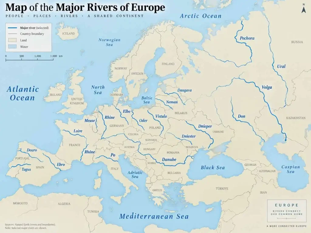
| River | Approx. length | Main countries | Drains into | Why it matters |
|---|---|---|---|---|
| Volga | 3,530 km | Russia | Caspian Sea | Longest and largest major European river system |
| Danube | 2,850 km | Germany to Ukraine | Black Sea | Major international river crossing or bordering 10 countries |
| Ural | 2,428 km | Russia, Kazakhstan | Caspian Sea | Traditionally associated with the Europe–Asia boundary |
| Dnieper | 2,200 km | Russia, Belarus, Ukraine | Black Sea | One of eastern Europe’s largest river systems |
| Don | 1,870 km | Russia | Sea of Azov | Major river of southern European Russia |
| Pechora | 1,809 km | Russia | Barents Sea | One of Europe’s major Arctic-draining rivers |
| Dniester | 1,352 km | Ukraine, Moldova | Black Sea | Important eastern European transboundary river |
| Rhine | 1,233 km | Switzerland to Netherlands | North Sea | Major navigation and economic corridor |
| Elbe | ~1,090 km | Czechia, Germany | North Sea | Major central European river |
| Vistula | 1,047 km | Poland | Baltic Sea | Longest river in Poland |
| Daugava | ~1,020 km | Russia, Belarus, Latvia | Baltic Sea | Important Baltic drainage river |
| Tagus | ~1,000 km | Spain, Portugal | Atlantic Ocean | Longest river of the Iberian Peninsula |
| Loire | ~1,006 km | France | Atlantic Ocean | Longest river wholly within France |
| Neman | ~937 km | Belarus, Lithuania and others | Baltic Sea | Major eastern Baltic river |
| Ebro | ~930 km | Spain | Mediterranean Sea | One of Spain’s principal river systems |
| Meuse | ~925 km | France, Belgium, Netherlands | North Sea system | Major transboundary river of western Europe |
| Douro | ~897 km | Spain, Portugal | Atlantic Ocean | Major Iberian river |
| Oder | ~854 km | Czechia, Poland, Germany | Baltic Sea | Important central European boundary river |
| Rhône | ~813 km | Switzerland, France | Mediterranean Sea | Major Alpine-Mediterranean river |
| Po | ~650 km | Italy | Adriatic Sea | Principal river of northern Italy |
River lengths should be treated as approximate rather than mathematically fixed values. Published figures can differ depending on the headwater selected, how bends are measured and where the mouth is defined. For example, modern sources give somewhat different values for the Volga and several other major European rivers. The geographical ranking is more important than apparent kilometer-level precision.
What Are the Five Major Rivers in Europe?
There is no officially recognized group of exactly five major European rivers.
If “major” means the five longest river systems usually treated as European, they are:
- Volga
- Danube
- Ural
- Dnieper
- Don
If “major” instead refers to continental economic, historical and international importance, a list is more likely to include the Volga, Danube, Rhine, Dnieper and Elbe.
That distinction explains why educational websites provide different answers. One commonly ranking page, for example, chooses the Danube, Loire, Elbe, Rhine and Volga, but that is a selected educational list rather than a geographical ranking by length.
For a geography reference, it is more useful to state the criterion than to imply that Europe has an official set of five major rivers.
What Is Europe’s Biggest River?
The Volga is Europe’s largest major river by several common measures.
It is approximately 3,530 kilometers long, making it Europe’s longest river. Its drainage basin covers about 1.36 million square kilometers, and published hydrological data place its average discharge near its lower course at roughly 8,060 cubic meters per second. It flows entirely through Russia before reaching the Caspian Sea.
So when “biggest” means longest, largest drainage basin or greatest average discharge among Europe’s major river systems, the Volga is generally the answer.
The phrase biggest river, however, is less precise than longest river, largest drainage basin or highest discharge.
The Longest Rivers in Europe
1. Volga River
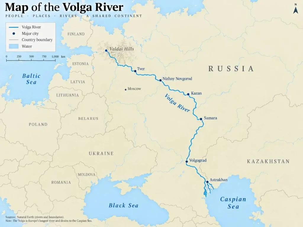
The Volga begins in the Valdai Hills of western Russia and runs southeast toward the Caspian Sea.
At roughly 3,530 kilometers, it is Europe’s longest river. Its basin covers approximately 1.36 million square kilometers, much of European Russia, making it a continental-scale drainage system rather than simply a long channel.
Large reservoirs and canals have substantially altered the Volga. Connections through Russia’s inland waterway network link the Volga system with other seas, giving the river an importance far beyond its natural Caspian drainage.
One unusual geographical feature is that the Volga is endorheic: its water reaches the landlocked Caspian Sea rather than eventually entering the world ocean.
2. Danube River
The Danube is approximately 2,850 kilometers long, making it Europe’s second-longest river after the Volga. It begins in Germany’s Black Forest and runs east and southeast to the Black Sea.
Its international geography is even more remarkable than its length. The river passes through or forms borders involving Germany, Austria, Slovakia, Hungary, Croatia, Serbia, Bulgaria, Romania, Moldova and Ukraine.
Four national capitals sit directly on the Danube:
- Vienna
- Bratislava
- Budapest
- Belgrade
Few European rivers connect as many countries, political regions and historic urban centers.
The Danube eventually spreads into the Danube Delta near the Black Sea, one of Europe’s most significant wetland landscapes.
3. Ural River
The Ural runs approximately 2,428 kilometers from Russia through Kazakhstan to the Caspian Sea. UNECE describes it as forming part of the traditional geographical boundary between Europe and Asia.
That produces an interesting classification issue: the Ural frequently appears as Europe’s third-longest river, yet it is also intimately connected with the conventional continental boundary itself.
This is a useful reminder that the edge of Europe is not defined by oceans on every side. The continent’s eastern boundary is partly conventional, commonly associated with the Ural Mountains and related geographic features.
4. Dnieper River
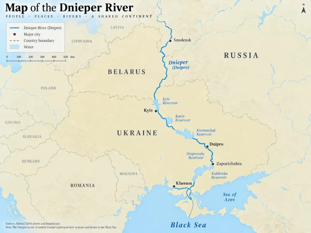
The Dnieper, or Dnipro in Ukrainian, is approximately 2,200 kilometers long.
It rises in western Russia, passes through Belarus and continues across Ukraine before reaching the Black Sea. It is one of the principal drainage systems of eastern Europe.
Cities developed along the Dnieper partly because the river historically provided transport, water and strategic access across the eastern European plain.
Its course has also been extensively modified by reservoirs and hydroelectric infrastructure.
5. Don River
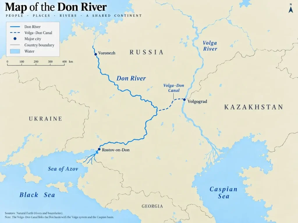
The Don runs approximately 1,870 kilometers across European Russia before reaching the Sea of Azov, which is connected to the Black Sea.
The river approaches the Volga in southern Russia, and the two systems are linked artificially by the Volga–Don Canal.
This connection is geographically important because it joins waterways ultimately associated with the Caspian and Black Sea basins.
6. Pechora River
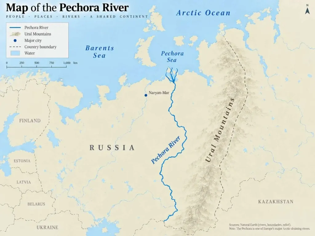
The Pechora differs from most of Europe’s better-known rivers because it flows north.
Beginning near the Ural Mountains, it crosses northeastern European Russia before emptying into the Pechora Sea, part of the Barents Sea and Arctic Ocean system.
At about 1,809 kilometers, it is one of Europe’s longest rivers and one of its largest Arctic-draining systems.
7. Dniester River
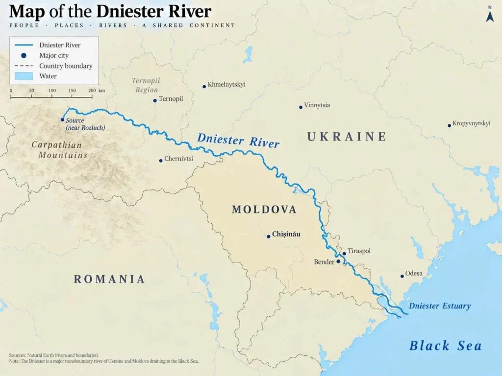
The Dniester runs for roughly 1,350 kilometers, primarily through Ukraine and Moldova, before reaching the Black Sea.
Its basin belongs to the broader group of eastern European waterways draining toward the Black Sea rather than toward the Atlantic or Baltic.
8. Rhine River
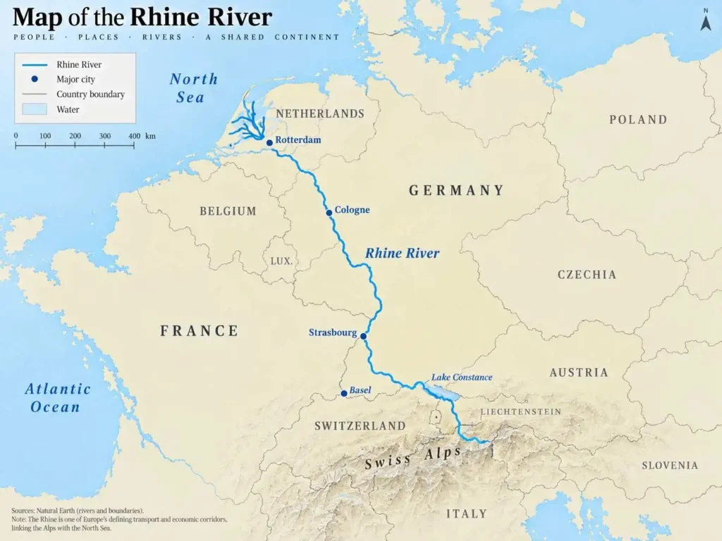
The Rhine is only about 1,233 kilometers long, but judging European rivers by length alone greatly understates its importance.
The International Commission for the Protection of the Rhine describes a basin of roughly 200,000 square kilometers shared by nine states, with more than 60 million people living within the catchment. The river connects the Alps with the North Sea.
It rises in the Swiss Alps, passes through or along several national boundaries and eventually reaches the Netherlands, where the lower river divides into a complex delta system.
For navigation, industry and settlement, the Rhine is one of Europe’s defining rivers.
Which Is Europe’s Most Famous River?
There is no objective geographical measurement of river “fame,” so no single river can formally hold that title.
The Danube and Rhine are probably the strongest candidates internationally.
The Danube links ten countries and four national capitals, while the Rhine has served for centuries as a major transport, political and cultural axis through western and central Europe. The Rhine remains an exceptionally important inland waterway; the Central Commission for the Navigation of the Rhine describes it in current reporting as Europe’s most important inland waterway.
The Volga is at least as important geographically because it is Europe’s largest river system, but much of its course lies within one country rather than across the highly interconnected urban belt of central and western Europe.
So:
Longest: Volga
Most internationally transboundary: Danube
Among the most important for European inland navigation: Rhine
Those are clearer geographical descriptions than trying to award one river the subjective title of “most famous.”
Major Rivers of Europe by Drainage Area
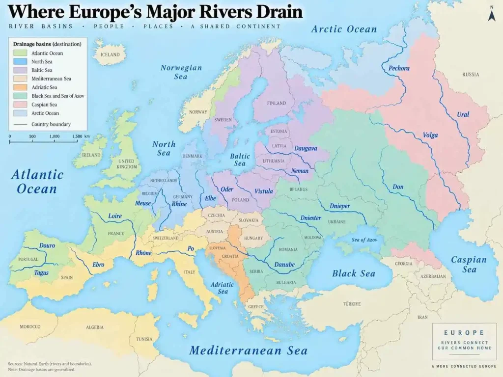
Another useful way to understand Europe’s rivers is to group them by the sea or ocean they eventually reach.
Caspian Sea Basin
The largest European river flowing into the Caspian is the Volga.
The Ural also reaches the Caspian farther east.
Because the Caspian has no natural outlet to the ocean, both belong to an endorheic drainage basin.
Black Sea and Sea of Azov Basins
Several of Europe’s longest rivers drain toward the Black Sea system:
- Danube
- Dnieper
- Dniester
- Don
The Danube enters the Black Sea directly, while the Don empties into the Sea of Azov, which connects to the Black Sea.
This is one reason eastern and southeastern Europe contain such a high concentration of the continent’s longest rivers.
North Sea Basin
Major rivers flowing toward the North Sea include:
- Rhine
- Elbe
- Meuse
Their drainage basins contain some of Europe’s most densely populated and industrialized regions.
The Rhine is particularly important. Its catchment encompasses parts of nine countries and supports tens of millions of residents.
Baltic Sea Basin
Important Baltic-draining rivers include:
- Vistula
- Oder
- Daugava
- Neman
- Neva
The Vistula is Poland’s largest river and runs approximately 1,047 kilometers before reaching the Baltic near Gdańsk.
Atlantic Ocean Basin
Western Europe’s Atlantic-facing rivers include:
- Loire
- Tagus
- Douro
- Shannon
- Seine, through the English Channel system
The Tagus crosses the Iberian Peninsula from Spain into Portugal before reaching the Atlantic at Lisbon.
The Loire is France’s longest river and reaches the Atlantic on the country’s western coast.
Mediterranean and Adriatic Basins
Among the major rivers draining toward the Mediterranean are:
- Rhône
- Ebro
- Po
The Rhône originates in the Swiss Alps, crosses Lake Geneva and southern France, and reaches the Mediterranean through its delta.
The Po drains northern Italy toward the Adriatic Sea and is the country’s longest river. WorldAtlas places its length at roughly 652 kilometers.
Arctic Ocean Basin
Northern European Russia contains large waterways flowing toward Arctic seas.
The Pechora is the most prominent example among Europe’s longest rivers. Other northern systems include the Northern Dvina and Mezen.
Why Are Europe’s Longest Rivers Mostly in the East?
A glance at a river map reveals an important pattern: most of Europe’s very longest rivers are in eastern Europe or European Russia.
There are several geographical reasons.
Eastern Europe contains extensive plains where rivers can travel great distances without reaching a nearby coast. European Russia in particular spans enormous east-west and north-south distances.
Western Europe is narrower and more deeply indented by the Atlantic, North Sea, Mediterranean and other coastal waters. Mountains such as the Alps and Pyrenees also divide drainage basins, giving many western rivers shorter routes to the sea.
That is why the Volga, Dnieper and Don greatly exceed rivers such as the Seine, Thames or Po in length even though the latter may pass through densely populated and economically important regions.
River Length Is Not the Same as River Importance
This is one of the biggest weaknesses in many lists of European rivers.
The Ural is almost twice as long as the Rhine, yet the Rhine has far greater importance for western European inland transport and connects one of the continent’s most densely populated economic regions.
Likewise, the Po is only around 650 kilometers long, yet its basin encompasses northern Italy’s major agricultural and industrial plain.
“Major river” can therefore refer to several different attributes:
- total length
- drainage basin area
- water discharge
- navigation
- population within the basin
- international boundaries
- hydroelectric production
- agricultural importance
- historic settlement
A good map of Europe’s rivers often tells more about the continent than a simple length ranking.
Rivers That Cross the Most European Countries
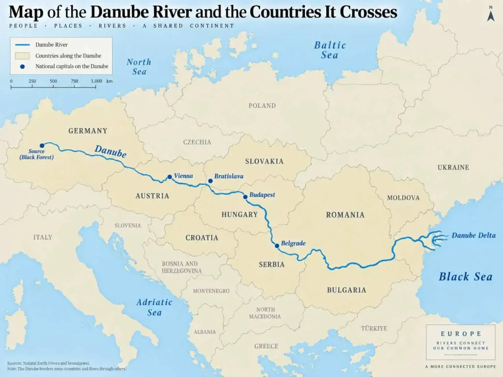
The Danube stands apart.
The Danube passes through or forms borders involving 10 countries on its journey from Germany to the Black Sea. Its wider drainage basin reaches still more countries.
The Rhine’s main channel directly interacts with fewer states, but its broader catchment extends across nine countries, according to the International Commission for the Protection of the Rhine.
This distinction matters:
Countries along a river’s main channel and countries containing part of its drainage basin are not the same thing.
A tributary may drain part of a country even though the main river never enters that country’s territory.
Why European Rivers Matter
Europe’s rivers are not simply physical features on a map.
They supply water, support agriculture, generate electricity, carry commercial traffic, provide aquatic habitat and influence settlement patterns. Because many basins cross national borders, river management is inherently international.
The European Union’s Water Framework Directive therefore manages water according to river basin districts, rather than treating national borders as hydrological boundaries. The European Commission specifically notes that many European river basins are international and require neighboring countries to cooperate.
European rivers also face increasing pressure from pollution, altered channels, dams, water abstraction, floods and drought.
The European Environment Agency’s Europe’s State of Water 2024 report says water stress affects about 20% of Europe’s territory and 30% of its population in an average year, while climate change is increasing concerns around drought and flooding.
A River Map of Europe Explains More Than a List
A useful map of European rivers should show more than individual blue lines.
It should make several large drainage patterns immediately visible:
- the Volga and Ural flowing toward the Caspian
- the Danube, Dnieper and Dniester draining toward the Black Sea
- the Rhine and Elbe reaching the North Sea
- the Vistula, Oder and Daugava draining toward the Baltic
- the Loire, Tagus and Douro reaching the Atlantic
- the Rhône, Ebro and Po draining toward Mediterranean seas
- northern Russian rivers running toward the Arctic
The European Environment Agency maintains a continent-wide river-catchment dataset organized by drainage basins and ocean outlets, illustrating why rivers are best understood as networks rather than isolated channels.
For this article, an original labeled map of Europe’s major rivers should be the primary body graphic.
The Bottom Line
Europe’s river geography cannot be reduced to one ranking.
The Volga is the continent’s longest and largest major river system, while the Danube is its great international river, connecting ten countries on its route to the Black Sea. The Rhine, although much shorter, is one of Europe’s most important navigation and economic corridors. Eastern Europe contains most of the continent’s very longest rivers, while western and southern Europe have shorter systems that often drain densely populated and economically important regions.
Understanding Europe’s rivers by length, drainage basin and outlet gives a much clearer picture than memorizing a list of names. Together, these waterways show how the continent’s mountains, plains, coastlines and seas organize the movement of water across Europe.
Frequently Asked Questions
There is no official set of five. By length, a practical top five is the Volga, Danube, Ural, Dnieper and Don. If “major” refers to economic and historical importance rather than length, the Rhine and Elbe are often included instead.
The Volga is Europe’s longest river at about 3,530 kilometers. It also has the continent’s largest major drainage basin, covering roughly 1.36 million square kilometers.
The Volga River is the longest river in Europe. It flows across western Russia from the Valdai Hills to the Caspian Sea.
The Danube, at about 2,850 kilometers, is Europe’s second-longest river after the Volga.
There is no objective “most famous” river. The Danube and Rhine are among the best-known internationally because of their history, major cities, navigation and cross-border geography.
The Danube passes through or forms borders with 10 countries between Germany and the Black Sea.
No. The Rhine is approximately 1,233 kilometers long, while the Danube is about 2,850 kilometers. The Rhine nevertheless has enormous economic importance as a European inland waterway.
Both concepts are involved. The Ural River lies in Russia and Kazakhstan and is conventionally associated with part of the boundary between Europe and Asia. That is why it is commonly included among Europe’s longest rivers even though its geography is transcontinental.
Definitions of western Europe vary, but the Rhine, at 1,233 kilometers, is among its longest major international rivers. France’s Loire is about 1,006 kilometers long, while the Tagus is longer if the Iberian Peninsula is included within the geographical definition being used.
If “biggest” means longest independent/main-stem rivers rather than tributaries, the upper group includes the Volga, Danube, Ural, Dnieper, Don, Pechora, Dniester, Rhine, Elbe, Vistula, Daugava, Tagus, Loire, Neman, Ebro, Meuse, Douro, Kuban, Mezen and Oder. Exact ordering can vary slightly because published river lengths differ by measurement method.

