

Germany’s major river systems are the Rhine, Danube, Elbe, Weser, Oder and Ems, the six highlighted by Germany’s Environment Agency. Important tributaries include the Main, Moselle, Neckar, Havel, Spree, Saale, Inn, Isar and Lech. Together, these waterways connect inland regions with the North Sea, Baltic Sea and Black Sea.
They form part of Europe’s major river systems, not a collection of separate rivers ending at Germany’s borders. The Danube has the longest full international course among rivers associated with Germany. The Rhine has the longest German-associated course. Those are different comparisons, as the length section below explains.
Major Rivers in Germany at a Glance
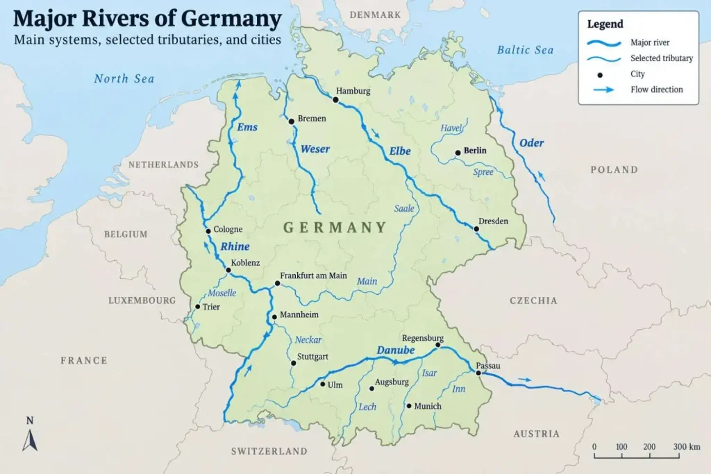
This selected overview groups tributaries beside their receiving systems. It is not a length ranking or a complete inventory. A tributary joins another river; a confluence is the place where rivers meet.
| River and local name | Example German city or region | Immediate recipient or outlet | Ultimate sea |
|---|---|---|---|
| Rhine / Rhein | Cologne | Netherlands delta and its outlets | North Sea |
| Main | Würzburg | Rhine at Mainz-Kostheim | North Sea |
| Moselle / Mosel | Trier | Rhine at Koblenz | North Sea |
| Neckar | Stuttgart | Rhine at Mannheim | North Sea |
| Danube / Donau | Regensburg | Danube Delta | Black Sea |
| Inn | Rosenheim | Danube at Passau | Black Sea |
| Isar | Munich | Danube near Plattling | Black Sea |
| Lech | Augsburg | Danube near Marxheim | Black Sea |
| Elbe | Dresden | Elbe estuary near Cuxhaven | North Sea |
| Havel | Western Berlin | Elbe near Gnevsdorf | North Sea |
| Spree | Central Berlin | Havel at Berlin-Spandau | North Sea |
| Saale, the Elbe tributary | Halle (Saale) | Elbe near Barby | North Sea |
| Weser | Bremen | Weser estuary at Bremerhaven | North Sea |
| Oder / Odra in Polish | Germany–Poland boundary | Szczecin Lagoon and connecting outlets | Baltic Sea |
| Ems | Northwestern Germany | Ems estuary and outer Ems | North Sea |
Reading the table: “Ultimate sea” traces the downstream connection; it does not mean every tributary enters that sea directly. Lengths are discussed separately because published figures do not always use matching source, mouth and headstream conventions.
What Is the Longest River in Germany?
Longest Full International Course: The Danube
The Danube is the longest river whose channel passes through Germany when its entire international course is counted. Austria’s waterway operator, viadonau, distinguishes two source conventions: 2,845 kilometers from the Breg–Brigach confluence at Donaueschingen, or 2,888 kilometers when the Breg headstream is included from its source near Furtwangen.
Neither figure describes the German section alone. Both continue downstream to the Black Sea. The choice of headwater changes the reported length without changing the river’s route through Germany.
Longest Course Within or Along Germany: The Rhine
The Rhine is the answer when the comparison concerns the course associated with Germany rather than the full international river. The Federal Institute of Hydrology’s Rhine overview gives approximately 870 kilometers in Germany, against 1,232.7 kilometers overall, or about 1,233 kilometers when rounded.
For a “within or along Germany” comparison, international boundary reaches belong in the German-associated course once, rather than being halved or counted twice. The 870-kilometer figure is BfG’s approximate description, not a new calculation of those reaches. Because official summaries differ and do not all explain their boundary treatment equally, this guide does not construct a precise German-section league table from mixed figures.
Longest Named River Entirely Within Germany: The Main
The Main is the conventional answer when separately named rivers are compared without extending the Weser upstream through the Werra. Its starting point needs care: the Aschaffenburg water authority measures 472 kilometers from the meeting of the White Main and Red Main, west of Kulmbach, to the Rhine at Mainz-Kostheim.
That is the named Main, not an extended course beginning at one of its headwater sources. The headstreams are treated separately, illustrating why an unexplained length above 500 kilometers should not be attached to the confluence-to-mouth course.
The Weser creates the corresponding complication. The Federal Institute of Hydrology’s Weser overview gives 427 kilometers for the named Weser from Hannoversch Münden to Bremerhaven. Adding the upstream Werra produces the longer Werra–Weser system, still within Germany, but changes the comparison from a named river to an extended system. There is no contradiction once the starting point is stated.
Germany’s Major River Systems
Rhine — Rhein
The Rhine begins in the Swiss Alps and reaches Germany’s southern border region through Lake Constance. Its German geography is easier to follow by separating the river into reaches.
The Rhine basin community’s description distinguishes the High Rhine toward Basel, the Upper Rhine toward Bingen, the Middle Rhine toward Bonn and the Lower Rhine toward the Netherlands. The broad Upper Rhine rift valley contrasts with the more confined Middle Rhine valley cut through the Rhenish Massif.
These reaches connect different tributary landscapes. The Neckar joins at Mannheim, the Main near Mainz and the Moselle at Koblenz. Farther downstream lie Cologne and Düsseldorf. The river continues beyond Germany into the Netherlands, where its waters divide among delta channels rather than following one simple line to the coast.
Danube — Donau
The Danube’s German course begins at Donaueschingen, where the Brigach and Breg meet. Its headwaters are in the Black Forest, but that does not make every location described as a “Danube source” the same measurement origin.
The Federal Institute of Hydrology’s Danube overview places the German river and its tributaries within a much larger drainage system. The course links southern German cities including Ulm, Ingolstadt and Regensburg before continuing toward Passau and Austria. The Lech, Isar and Inn bring water from the south into this system.
At Passau, the Ilz joins the Danube from one side and the Inn from the other. Below these confluences, the name remains Danube. Its eventual destination is the Black Sea, far beyond the German reach.
Elbe
The Elbe rises in the Krkonoše, or Giant Mountains, in Czechia and continues into eastern Germany. Dresden and Magdeburg stand on its German course; farther downstream, the river passes Hamburg and reaches the North Sea through its estuary near Cuxhaven.
The Federal Institute of Hydrology’s Elbe overview identifies tributaries including the Mulde, Saale and Havel. Below the Geesthacht weir, tides influence the lower river. An estuary is the downstream transition where river water encounters the sea and its tidal influence.
Berlin shows why the river and its basin must be distinguished. The capital lies within the Elbe catchment, but it is not on the Elbe’s main channel. Its Spree and Havel connections explain how Berlin’s water reaches the Elbe indirectly.
Weser
The Weser begins at Hannoversch Münden, where the Werra meets the Fulda. Its headstreams originate in different upland regions: the Werra in the Thuringian Forest and the Fulda in the Rhön.
Downstream, the river passes from the Weser uplands through Porta Westfalica into the North German Plain. Bremen lies on the lower course, followed by the estuary toward Bremerhaven. The wider system also includes the Aller and other tributary regions.
One mapping detail matters: the administrative Weser river basin district includes the neighboring Jade catchment. That does not make the Jade a branch of the Weser. A management district can combine separate drainage areas, just as a river-system length can combine differently named channels.
Oder — Odra in Polish
The Oder rises in the Oderské Vrchy in Czechia, continues through Poland and forms part of Germany’s eastern boundary with Poland. It does not form that entire international border.
According to the Federal Institute of Hydrology’s Oder description, the river enters the Szczecin Lagoon, whose connecting outlets carry water to the Baltic Sea. Naming the lagoon preserves a geographical step that disappears when the mouth is described simply as “the Baltic.”
The Warta and Lusatian Neisse are important tributaries. The latter is a separate river, not another name for the Oder.
Ems
The Ems begins in the western foothills of the Teutoburg Forest and crosses northwestern Germany toward the North Sea. Its lowland course belongs to a different setting from the Alpine tributaries farther south.
The Federal Institute of Hydrology’s Ems overview distinguishes the river, its tidal and coastal waters, and connections with the Dortmund–Ems Canal. The Hase and Leda contribute to the drainage network.
The lower Ems also has a German–Dutch estuarine context. Describing the entire source-to-sea setting as exclusively German would overlook those shared coastal waters. Likewise, an engineered canal connection should not be mistaken for the river’s natural source or treated as a separate natural river.
Important Tributaries and Urban Rivers
Main, Moselle and Neckar: The Rhine System
The Main connects Franconia with the Rhine. Würzburg and Aschaffenburg lie along its course, while Frankfurt am Main occupies its lower section. Its proper name is Main: it is not a label for whichever river happens to be most important in a city.
The Moselle, called Mosel in Germany, rises in France’s Vosges Mountains. The Moselle and Saar commissions’ geographical description traces it through France, along the Germany–Luxembourg boundary and onward past Trier to Koblenz. The Saar joins it at Konz, so the downstream sequence is Saar → Moselle → Rhine → North Sea.
The Neckar has its origin in the Schwenninger Moos near Villingen-Schwenningen. Its course links Stuttgart with the Rhine at Mannheim; Heidelberg lies on its lower reach.
Havel, Spree and Saale: The Elbe System
The Havel and Spree are separate rivers with a direct connection in Berlin. Berlin’s environmental authority places the Spree’s meeting with the Havel at Spandau. The Havel subsequently reaches the Elbe near Gnevsdorf.
The resulting pathway is Spree → Havel → Elbe → North Sea. The Spree does not flow directly into the Elbe, and the Havel is not a tributary of the Spree. The Havel’s source lies in Mecklenburg, while the Spree’s headwaters lie in Saxony.
The Saale discussed here is the Elbe tributary, not the Franconian Saale in the Main system. It rises in the Fichtelgebirge, passes through Halle and continues toward its Elbe confluence near Barby. The Weiße Elster joins the Saale in southern Halle, adding another level to the tributary network.
Inn, Isar and Lech: The Danube System
These rivers help explain why a river associated with Bavaria need not rise in Germany.
The Inn begins in the Swiss Alps and crosses Austria before reaching Germany. In Bavaria it passes Rosenheim; parts of its route form the Germany–Austria boundary before its confluence with the Danube at Passau.
The Isar rises in Austria’s Karwendel Mountains. Its course passes through Bad Tölz, Munich, Freising and Moosburg before reaching the Danube near Plattling. Its landscape includes gravel-rich river sections and the transition from Alpine surroundings into the foreland.
The Lech also rises in Austria, near the Formarinsee. It passes Augsburg and meets the Danube near Marxheim. All three feed the Black Sea drainage system through the Danube, rather than entering the sea independently.
Where Do Germany’s Rivers Drain?
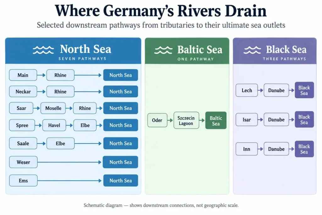
A drainage basin, or catchment, is the area whose water feeds a river and its tributaries. The river channel is only one part of that area. A drainage divide separates neighboring catchments, so rain falling on opposite sides may follow very different downstream routes.
Germany’s principal destinations are the North Sea, Baltic Sea and Black Sea. Among the six systems introduced here, the Rhine, Elbe, Weser and Ems lead toward the North Sea; the Oder reaches the Baltic through its lagoon connection; and the Danube continues to the Black Sea. Smaller coastal catchments also exist outside these major systems.
The Meuse provides another important qualification. German tributary areas belong to the Meuse basin even though the Meuse’s main channel runs through France, Belgium and the Netherlands, not Germany.
For example, the Rur flows from Belgium through Germany to the Meuse at Roermond in the Netherlands. Its water eventually reaches the North Sea. The Rur should not be confused with the similarly named Ruhr, which belongs to the Rhine system.
This network is why “German rivers flow north” is an unreliable rule. Downstream direction follows the landscape and its drainage connections, not the top of a map. The Danube’s route toward Austria is an obvious counterexample.
Which Rivers Flow Through Germany’s Major Cities?
| City | River or rivers | Important qualification |
|---|---|---|
| Berlin | Spree and Havel | The Spree joins the Havel at Spandau; Berlin is not on the Elbe itself. |
| Frankfurt am Main | Main | Part of the Rhine system, not a city on the Rhine’s main channel. |
| Frankfurt (Oder) | Oder | A different city on Germany’s eastern border. |
| Munich | Isar | In the Danube basin, but not on the Danube. |
| Hamburg | Elbe | On the tidal lower river; not every local waterway is the Elbe. |
| Bremen | Weser | On the river’s lower course, upstream of Bremerhaven. |
| Koblenz | Rhine and Moselle | The Moselle joins the Rhine here. |
| Passau | Danube, Inn and Ilz | Two confluences connect all three; the downstream river remains the Danube. |
The distinction is practical: “in the Danube basin” tells you about drainage, while “on the Danube” identifies the actual channel beside a city.
Why Germany’s Rivers Matter
River geography helps explain transport routes, water use and habitats, but natural drainage and engineered connections should remain separate.
The Main–Danube Canal creates a navigable connection between the Main–Rhine and Danube systems. The Hof water authority describes it crossing the European drainage divide. Ships can move between systems without the canal becoming a natural tributary or erasing the distinction between their catchments.
Rivers also carry sediment and support connected habitats along their beds and floodplains. Straightening, barriers and altered flows can change those relationships. River modification and restoration can therefore alter local habitats without implying that every German river has the same condition.
Water supply adds another connection between channels and the surrounding landscape. The Saale–Weiße Elster floodplain, for example, has played an important role in Halle’s water-supply history. Understanding a river therefore requires looking beyond its length to its tributaries, floodplain and uses.
The Bottom Line
Germany’s rivers are most useful to understand as connected systems. Follow each channel to its immediate recipient, then to its ultimate sea. Keep cities on tributaries separate from cities on the main river, and distinguish a full international length from the German reach. Those habits explain the Rhine–Danube comparison, Berlin’s connection to the Elbe and the Main–Weser naming question without reducing the country’s geography to a single ranking.
Frequently Asked Questions
The six major systems identified by Germany’s Environment Agency are the Rhine, Danube, Elbe, Weser, Oder and Ems. They are a useful starting framework, not a count of all rivers. Tributaries such as the Main, Spree and Isar explain much of the country’s regional and urban geography.
The Danube is longest when its full international course is counted. The Rhine is longest when considering its German-associated course. These answers use different geographical extents. A length comparison should state its starting point, mouth and treatment of international border sections.
The Main is commonly identified as the longest separately named river wholly within Germany. The Weser also remains within Germany, and including its Werra headstream creates a longer system. A named-river comparison and a headstream-inclusive comparison should not be presented as the same ranking.
The Spree runs through central Berlin and meets the Havel at Spandau. The Havel occupies a separate course through western Berlin and continues toward the Elbe. Consequently, Berlin belongs to the Elbe drainage basin without standing on the Elbe’s main channel.
No. The Oder system reaches the Baltic Sea through the Szczecin Lagoon and connecting outlets, while the Danube system drains to the Black Sea. The North Sea receives the Rhine, Elbe, Weser and Ems systems, as well as other drainage connections.
A defensible total requires a definition of what counts as a river. Germany’s Environment Agency describes a flowing-water network exceeding 500,000 kilometers. That is network length, including streams, not a count of individual rivers or named channels.
Sources may start at different headwaters, stop at different mouth locations or use different mapping conventions. Navigation distances are another distinct measurement. BfG’s Weser overview, for example, describes navigation chainage restarting at Bremen. Unexplained differences should not be averaged into an apparently more precise answer.