

Italy’s rivers make much more sense once you look at the shape of the country.
The Alps collect water across the north, the Po Valley gives one river enough room to grow into a large continental-style system, and the Apennines split the long Italian Peninsula into dozens of shorter routes to the sea.
That is why the Po, at about 652 kilometers (405 miles), dominates northern Italy while rivers farther south are usually shorter and more regional. The Adige, at about 410 kilometers, is Italy’s second-longest major river, followed closely by the Tiber, which runs through Rome for part of its roughly 405-kilometer course.
Some of Italy’s best-known cities are closely tied to rivers:
- Rome — Tiber
- Florence — Arno
- Turin — Po
- Verona — Adige
What matters more than the numbers, though, is the pattern behind them. Italy’s rivers show how mountains, plains, lakes, and coastlines shape the way water moves across the country.
The Pattern Behind Italy’s Rivers
Most of northern Italy is tied to large Alpine catchments and the Po system. Farther south, the Apennines act as a long drainage divide, sending rivers toward different sides of the peninsula.
In simple terms:
- Alps → large northern catchments
- Po Valley → room for one major river system
- Apennines → shorter east- and west-flowing rivers
Once that pattern is clear, the rest of Italy’s river geography becomes much easier to understand.
Map of the Major Rivers in Italy
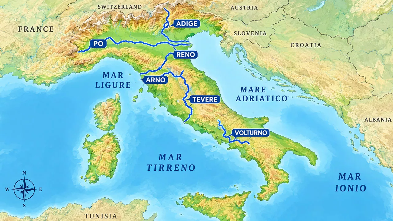
A useful map should show the Po, Adige, Tiber, Arno, Ticino, Adda, Oglio, Tanaro, Piave, Reno, Volturno, and the Italian headwaters of the Drava.
It should also show the Alps, Apennines, Po Valley, Lake Maggiore, Lake Como, Lake Iseo, Adriatic Sea, Tyrrhenian Sea, and Ligurian Sea.
The main thing to notice is how different northern Italy looks from the rest of the peninsula. The north has a much more connected river-and-lake system, while central and southern Italy are broken into smaller drainage basins by the Apennines.
The Rivers That Shape Italy
| River | Approx. Length | Geographic Setting | Major Place | Directly Empties Into |
| Po | 652 km (405 mi) | Northern Italy / Po Valley | Turin | Adriatic Sea |
| Adige | 410 km (255 mi) | Alpine / northeastern Italy | Verona | Adriatic Sea |
| Tiber | 405 km (252 mi) | Apennine / central Italy | Rome | Tyrrhenian Sea |
| Adda | 313 km (194 mi) | Alpine / Lombardy | Lake Como | Po |
| Oglio | 280 km (174 mi) | Alpine / Lombardy | Lake Iseo | Po |
| Tanaro | 276 km (171 mi) | Ligurian Alps / Piedmont | Alessandria area | Po |
| Ticino | 248 km (154 mi) total | Transboundary Alpine river | Pavia | Po |
| Arno | 241 km (150 mi) | Apennine / Tuscany | Florence, Pisa | Ligurian Sea |
| Piave | about 220 km (137 mi) | Eastern Alps / Veneto | Veneto | Adriatic Sea |
| Reno | about 211 km (131 mi) | Northern Apennines | Emilia-Romagna | Adriatic Sea |
| Volturno | about 175 km (109 mi) | Southern Apennines | Campania | Tyrrhenian Sea |
A Note on River Lengths
River lengths can vary slightly by source.
Different references may choose different headwaters, measure winding channels differently, or include international sections in different ways.
The Ticino, for example, crosses both Switzerland and Italy.
The Drava is an even more unusual case. It begins in Italy but spends almost all of its journey outside the country. Its total length is much greater than the Po’s, but that does not make it the longest river flowing through Italy in the usual geographic sense.
The Po remains the river with the longest course within Italian territory.
Po River: The Great River of Northern Italy
The Po is the one Italian river that feels continental in scale.
Instead of dropping quickly from mountains to sea, it crosses a broad plain between the Alps and Apennines, collecting tributaries from both sides as it moves east.
The river rises near Monte Viso in the Cottian Alps and runs for about 652 kilometers before reaching the Adriatic.
Its major tributaries include:
- Ticino
- Adda
- Oglio
- Mincio
- Dora Baltea
- Tanaro
Several of those rivers also connect the Po with northern Italy’s large lakes.
- Ticino → Lake Maggiore → Po
- Adda → Lake Como → Po
- Oglio → Lake Iseo → Po
That combination of Alpine headwaters, large lakes, tributaries, and a broad lowland explains why the Po became Italy’s dominant river system.
The Po River Is Not the Same as the Po Basin
The Po itself is the main channel.
The Po Basin is the much larger area whose water eventually drains into that channel, either directly or through tributaries.
That distinction explains why Milan belongs to the wider geography of the Po Plain even though the main river does not pass through the city.
A place can sit inside a river basin without sitting on the river itself.
The Po Delta
Near the Adriatic coast, the Po breaks into several distributary channels and spreads across the Po Delta.
The landscape here is a mix of river channels, marshes, lagoons, wetlands, agricultural land, and sediment-built coastal terrain.
This is where the Po stops behaving like a single river and becomes a much broader coastal landscape.
Adige River: A Separate Alpine Route to the Sea
The Adige is about 410 kilometers long and is Italy’s second-longest major river.
It begins near Reschen Pass in the Alps and flows through northeastern Italy, passing places such as Merano, Bolzano, Trento, Rovereto, and Verona before reaching the Adriatic.
The key point is easy to miss:
- The Adige does not join the Po.
- Both rivers cross northern Italy and both eventually reach the Adriatic, but they belong to separate drainage systems.
- That makes northern Italy more hydrologically complex than a simple map of the Po basin might suggest.
Tiber River: The River That Defines Rome
The Tiber, or Tevere in Italian, is about 405 kilometers long.
It rises in the Apennines and flows through central Italy before reaching Rome and continuing toward the Tyrrhenian coast.
The Tiber matters far more for Rome than for its size.
What River Runs Through Rome?
The Tiber River runs through Rome.
Its role in the city goes back to antiquity. The river provided water, transport, and a route between inland Rome and the coast.
It also shows how peninsular Italian rivers differ from the Po. The Tiber begins in the Apennines and crosses a much narrower stretch of land before reaching the sea.
Arno River: Tuscany’s Best-Known River
The Arno is smaller than the Tiber or Po, but its cultural footprint is enormous.
The river rises on Monte Falterona in the Apennines and runs for about 241 kilometers across Tuscany.
It passes through Florence, continues through Pisa, and reaches the Ligurian Sea at Marina di Pisa.
What River Runs Through Florence?
The Arno River runs through Florence.
It passes beneath some of the city’s best-known bridges, including the Ponte Vecchio, before continuing west across Tuscany.
The Arno is a classic Apennine river: important regionally, closely tied to major cities, but limited in length by the relatively short distance between mountain headwaters and the coast.
Other Important Rivers in Italy
Several other rivers help explain how Italy’s drainage systems fit together.
| River | Why It Matters |
| Adda | Flows from the Alps through Lake Como before joining the Po |
| Oglio | Passes through Lake Iseo before joining the Po |
| Tanaro | Major tributary entering the Po from the southern side of the valley |
| Ticino | Crosses Switzerland and Italy, passes through Lake Maggiore, then joins the Po |
| Piave | Independent Alpine river flowing directly to the Adriatic |
| Reno | Northern Apennine river draining toward the Adriatic |
| Volturno | Major Campanian river flowing toward the Tyrrhenian Sea |
Two patterns stand out.
First, several northern rivers pass through large lakes before joining the Po.
Second, not every important northern river belongs to the Po system. The Adige and Piave take their own routes to the Adriatic.
Why Northern and Southern Italy Have Such Different Rivers
The difference comes down to terrain.
The Alps Feed Large Catchments
The Alps form a huge mountain arc across northern Italy.
Rivers such as the Adige, Ticino, Adda, Oglio, and Piave all draw water from Alpine terrain, while many others become tributaries of the Po.
The Alps also sit at the meeting point of several major European drainage systems. Nearby headwaters can eventually send water toward the Adriatic, North Sea, western Mediterranean, or Black Sea.
The Po Valley Gives One River Room to Grow
The Po Valley is the reason Italy has one river system much larger than the rest.
The Po does not have to descend directly from mountains to sea. It has a broad east-west plain to cross.
As it moves across that plain, tributaries arrive from the Alps to the north and the Apennines to the south.
The result is Italy’s largest integrated drainage basin.
The Apennines Split the Peninsula
The Apennines run down much of Italy and act like a long central spine.
Rivers on one side may flow toward the Adriatic, while rivers beginning not far away on the other side may drain west.
Because the peninsula is narrow, many of these rivers reach the coast after relatively short journeys.
That contrast becomes even clearer when Italy is set beside the Volga, Danube and Rhine, which have much larger continental interiors to cross.
Where Do Italy’s Major Rivers Drain?
Most Italian rivers ultimately reach Mediterranean waters, but not all on the same side of the country.
Toward the Adriatic
Important rivers reaching the Adriatic directly or through larger systems include:
- Po
- Adige
- Piave
- Reno
- Brenta
- Tagliamento
The Po dominates this side by basin size.
Toward the Western Coast
Important western-draining rivers include:
- Tiber
- Arno
- Volturno
The Tiber and Volturno reach the Tyrrhenian side, while the Arno reaches the Ligurian Sea.
The Apennines are the key divide between these drainage directions.
The Drava: Italy’s Black Sea Connection
One of the most surprising facts about Italian river geography is that not every drop of water beginning in Italy ends up in the Mediterranean.
The Drava begins near Sella di Dobbiaco in South Tyrol.
Instead of flowing south, it heads east and eventually joins the Danube. The Danube then continues all the way to the Black Sea.
That creates an interesting technicality.
The Drava is much longer overall than the Po, but only a very small part of its course lies in Italy.
The Po is still the longest river by course within Italian territory.
The Drava also shows something larger about geography:
Political borders do not decide where water flows. Watersheds do.
The same Danube system also appears among the Rhine, Danube, Elbe and other major rivers crossing Germany, where river basins divide the country between several different seas.
Major Italian Cities and Their Rivers
| City | River | Relationship |
| Rome | Tiber | River crosses the city |
| Florence | Arno | River crosses the historic center |
| Turin | Po | Po passes through the city |
| Verona | Adige | Adige curves through the city |
| Pisa | Arno | Arno crosses Pisa before reaching the coast |
| Pavia | Ticino | Ticino passes through the city before joining the Po |
| Milan | — | Lies in the Po Plain but not on the main Po channel |
This is a useful reminder that a city on a river and a city inside a river basin are not the same thing.
Italy Compared With France and Germany
Italy’s river pattern is quite different from that of larger continental countries nearby.
France has several major independent systems. The Loire, Seine, Rhône and Garonne drain toward different coasts and are not dominated by one single national basin.
Germany is more continental again, with rivers such as the Rhine, Elbe, and Danube crossing much broader inland landscapes.
Italy has less space for that kind of development. Outside the Po Valley, the peninsula is simply too narrow for most rivers to become very long.
Final Takeaway
Italy’s rivers are really a story about shape and relief.
The broad north gives the Po room to grow into the country’s dominant river system, while the Apennines keep most other rivers shorter and more regional. The Adige, Tiber, Arno, Piave, and Volturno each reflect a different part of that pattern.
Even the Drava adds to the picture by showing that Alpine watersheds can send Italian water toward the Black Sea.
Once that pattern is clear, the map of Italy’s rivers becomes much easier to read.
Frequently Asked Questions
The Po is the longest river by distance flowing within Italy, at about 652 kilometers (405 miles).
Yes, overall. But almost all of the Drava lies outside Italy. The Po has the longest river course within Italian territory.
The leading major rivers are the Po at about 652 km, the Adige at about 410 km, and the Tiber at about 405 km.
The Tiber River runs through Rome.
The Arno River runs through the heart of Florence, passing beneath some of the city’s best-known bridges before continuing west through Tuscany. It later flows through Pisa and reaches the Ligurian Sea near Marina di Pisa.
No. Milan lies in the wider Po Plain, but the main channel of the Po passes farther south.

