

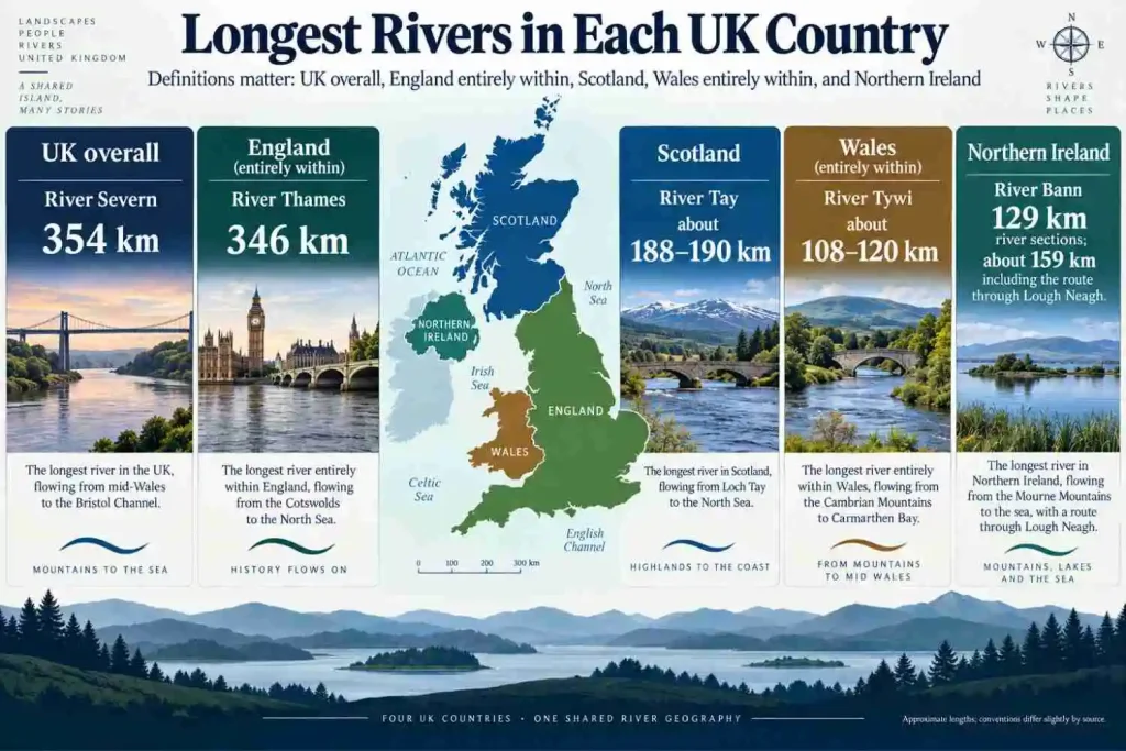
The UK’s major rivers include the Severn, Thames, Trent, Great Ouse, Wye, Tay, Clyde, Spey, Tweed, Tywi and Bann. The Severn is the UK’s longest river at about 354 km (220 miles), rising in Wales and flowing through England to the Severn Estuary. The Thames is slightly shorter at 346 km (215 miles), but it is the longest river entirely within England.
The picture changes across the four countries of the UK. England contains several long lowland rivers, Wales and Scotland have steep upland catchments, and Northern Ireland adds the unusual Bann–Lough Neagh system plus river basins that cross the international boundary with the Republic of Ireland.
Major Rivers in the UK at a Glance
The table uses approximate named-river or clearly defined source-to-mouth lengths. It does not treat an estuary, navigable reach or total catchment watercourse network as though it were the river itself.
| River | Approx. Length | UK Country/Countries | Major Place | Immediate Outlet / Receiving Water | Key Qualification |
|---|---|---|---|---|---|
| Severn | 354 km | Wales, England | Shrewsbury, Worcester, Gloucester | Severn Estuary → Bristol Channel | Longest river in the UK |
| Thames | 346 km | England | Oxford, Reading, London | Thames Estuary → North Sea | Longest river entirely within England |
| Trent | 297 km | England | Nottingham area | Yorkshire Ouse at Trent Falls → Humber | Does not retain the name Trent to the sea |
| Wye | about 250 km | Wales, England | Hereford, Monmouth | Severn Estuary | Crosses and follows parts of the Wales–England boundary |
| Great Ouse | about 230 km | England | Bedford, Huntingdon, Fenland | The Wash → North Sea | Not the same river as the Yorkshire Ouse |
| Tay | about 188–190 km | Scotland | Perth | Firth of Tay → North Sea | Scotland’s longest river; length and discharge are separate metrics |
| Spey | about 169 km | Scotland | Speyside | Moray Firth → North Sea | Major Highland river |
| Clyde | about 170 km | Scotland | Glasgow | Clyde Estuary / Firth of Clyde | River and firth are not the same feature |
| Tweed | about 156 km | Scotland, England | Berwick-upon-Tweed | North Sea | Crosses and forms sections of the Scotland–England boundary |
| Tywi | published NRW figures vary: about 108–120 km | Wales | Carmarthen | Carmarthen Bay | Commonly identified as the longest river entirely within Wales |
| Bann | 129 km of Upper + Lower Bann river sections | Northern Ireland | Portadown, Coleraine | Atlantic Ocean | Full source-to-sea route through Lough Neagh is longer |
UK, Great Britain and England Are Not the Same Thing
River rankings become confusing when UK, Great Britain, Britain and England are treated as synonyms.
The United Kingdom includes England, Scotland, Wales and Northern Ireland.
Great Britain is the island containing England, Scotland and Wales. Northern Ireland is part of the UK but not part of Great Britain.
That distinction matters here. The Severn is the longest river in the UK and Great Britain, but it rises in Wales and then flows through England. The Thames lies entirely within England.
So “longest river in the UK” and “longest river entirely within England” are different geographic questions.
What Is the Longest River in the UK?
The River Severn is the UK’s longest river at about 354 km (220 miles). The Environment Agency describes the Severn as the UK’s longest river, running from its source in mid Wales to the Severn Estuary.
River Severn: Longest River in the UK
The Severn rises on the slopes of Pumlumon, also widely known in English as Plynlimon, in the Cambrian Mountains of Wales.
It initially flows through Wales before crossing into England. Farther downstream it passes Shrewsbury, Worcester and Gloucester, then widens into the Severn Estuary before reaching the Bristol Channel.
The Vyrnwy, Teme and Warwickshire Avon are among its important tributaries.
The important measurement boundary is at the lower end: the River Severn and the Severn Estuary are connected but not identical geographic features. A river-length figure should not silently continue through the estuary to the open sea.
River Thames: Longest River Entirely Within England
The Thames is about 346 km (215 miles) long and is the longest river entirely within England. The Thames Rivers Trust uses the 346 km figure and identifies Thames Head near Kemble in the Cotswolds as the source.
The river passes through Oxford, Reading and Windsor before reaching London. Below Teddington, it becomes tidal, and the lower river opens into the Thames Estuary before reaching the North Sea.
The Cherwell, Kennet, Lea/Lee and Wey are among its major tributaries.
Why the Severn and Thames Answers Are Different
The Severn is longer overall, but it is a Wales-and-England river.
The Thames is shorter overall, but its full course remains within England.
So:
- Longest river in the UK: Severn
- Longest river that passes through England: Severn
- Longest river entirely within England: Thames
Those statements do not conflict. They use different geographic definitions.
The Longest River in Each UK Country
England
If the question means the longest river that enters England, the answer is the Severn.
If it means the longest river wholly within England, the answer is the Thames, at about 346 km.
That distinction should always be stated rather than hiding it behind the phrase “longest river in England.”
Scotland
The River Tay is Scotland’s longest river, at roughly 188–190 km under the common source-to-estuary convention used by Scottish sources.
The Tay system begins in the western Highlands, passes through major lochs including Loch Tay, flows through Perth and reaches the Firth of Tay.
Length is not its only notable metric. NatureScot describes the Tay as having the highest mean flow of any watercourse in Britain, which is a discharge statement rather than another way of saying “longest.”
Wales
The Severn rises in Wales, but it does not remain there.
The Afon Tywi / River Tywi is commonly identified as the longest river flowing entirely within Wales. Natural Resources Wales material, however, gives different approximate lengths. A recent restoration article describes a 120 km course, while another NRW landscape description gives 108 km.
This guide therefore does not manufacture a single exact figure. The geographical point is more secure than the kilometer-level precision: the Tywi rises in the Cambrian Mountains, passes through the Tywi valley and Carmarthen, and reaches Carmarthen Bay.
Northern Ireland
The River Bann is Northern Ireland’s longest river system, but its length requires a definition because Lough Neagh interrupts the named river channel.
The Upper Bann flows into Lough Neagh. The Lower Bann begins at the northern end of the lough and continues to the Atlantic near the north coast.
A widely used river-channel figure is about 129 km for the Upper and Lower Bann combined. If the route across Lough Neagh is included in the source-to-sea distance, the total becomes roughly 159 km.
Northern Ireland government material confirms the physical structure of the system: the Bann is the principal river system of the Neagh Bann district, with Lough Neagh at its centre and the Lower Bann carrying water to the Atlantic.
Major Rivers of England
Thames
The Thames is England’s best-known river and its longest fully domestic river.
It connects the Cotswold headwaters with Oxford, the middle Thames valley, London and the North Sea. Its lower tidal reach is not simply another rural river segment: tides affect the Thames through central London well upstream of the estuary.
Trent
The River Trent, about 297 km long, drains a large part of the English Midlands.
It flows past or near major urban areas including Stoke-on-Trent and Nottingham. The river runs along the southern side of Nottingham rather than cutting through its central core in the way the Thames does through central London.
Here is the more important downstream distinction:
Trent → Yorkshire Ouse → Humber Estuary → North Sea
At Trent Falls, the Trent meets the Yorkshire Ouse. The combined estuarine system is called the Humber. The Trent therefore does not simply continue to the North Sea under the same name.
Great Ouse
The Great Ouse is about 230 km long and drains a broad part of eastern England.
It begins in the Midlands, passes through Bedford and the Fens region, and reaches The Wash, which opens into the North Sea.
The Environment Agency calls it the fourth-longest river in the United Kingdom. It should not be confused with the Yorkshire Ouse, which joins the Trent to form the Humber.
Tyne and Mersey
The Tyne reaches the North Sea between Newcastle and Tynemouth. Newcastle upon Tyne stands directly on the river.
The Mersey drains toward the Irish Sea. Liverpool is best described as standing on the Mersey Estuary, rather than simply treating the broad tidal water beside the city as an ordinary inland river reach.
Major Rivers of Wales
Severn
The Severn begins in the Welsh uplands before crossing into England, making it one of the clearest examples of a UK river whose drainage ignores an internal national boundary.
Wye
The River Wye also rises near Pumlumon and follows a long course through Wales and England.
It passes Hereford and Monmouth and reaches the Severn Estuary. Sections of the river also coincide with the Wales–England boundary, but the whole river is not a political border.
Tywi
The Tywi stays within Wales and is therefore the answer to a different longest-river question from the Severn.
Its upper catchment lies in the Cambrian Mountains. Downstream, the river passes Llandovery, Llandeilo and Carmarthen before entering Carmarthen Bay.
Welsh Dee
The Welsh Dee, or Afon Dyfrdwy, rises in Wales, flows through north Wales and then enters England near Chester before reaching the Dee Estuary.
Do not confuse it with the Scottish River Dee, which flows through Aberdeenshire to the North Sea at Aberdeen.
Major Rivers of Scotland
Tay
The Tay is Scotland’s longest river and the country’s dominant river by several additional hydrological measures.
It flows through Perth before widening into the Firth of Tay. The River Tay and Firth of Tay should remain separate terms in both maps and length tables.
Clyde
The Clyde flows through Glasgow and becomes increasingly tidal downstream.
The river leads toward the Clyde Estuary and then the Firth of Clyde. Calling the entire firth “the River Clyde” would blur a real geographic transition between river, estuary and coastal water.
Spey
The Spey drains part of the Scottish Highlands and reaches the Moray Firth.
Its course is shorter than the Tay’s but still places it among Scotland’s major rivers. Mountain relief, high rainfall and steep gradients give Highland rivers a different character from many lowland English systems.
Tweed
The Tweed rises in southern Scotland and eventually reaches the North Sea at Berwick-upon-Tweed in England.
Parts of its lower course cross or coincide with the Scotland–England boundary. That does not mean the entire river forms the national boundary.
Scottish Dee
The Scottish Dee drains the Cairngorms and reaches the North Sea at Aberdeen.
It is a completely different river from the Welsh Dee. A national UK river map must distinguish them clearly.
Major Rivers of Northern Ireland
Bann and Lough Neagh
Northern Ireland adds a river configuration that does not fit neatly into a standard source-to-sea table:
Upper Bann → Lough Neagh → Lower Bann → Atlantic Ocean
Lough Neagh is a lake, not merely a widened reach of river. The river-name sequence resumes as the Lower Bann at the lake’s northern outlet.
That is why published Bann lengths can differ depending on whether the lake crossing is included.
Lagan
The River Lagan flows through Belfast and reaches Belfast Lough.
The lower river is tidal, so Belfast’s river geography also involves an estuarine transition rather than an abrupt river-to-sea line.
Foyle
The River Foyle flows through Derry/Londonderry before entering Lough Foyle.
Its catchment is cross-border. The river system includes tributaries and headwaters on both sides of the UK–Republic of Ireland boundary.
Erne
The Erne system also crosses the international boundary.
Its catchment extends through the Republic of Ireland and Northern Ireland, including Upper and Lower Lough Erne in County Fermanagh, before the system returns toward the Atlantic in County Donegal.
The Foyle and Erne make an important geographic point: the political boundary on the island of Ireland does not function as a drainage divide.
Why Are UK Rivers Relatively Short?
The UK has important rivers, but none approaches the length of continental giants such as the Volga, Danube or Rhine.
The main reason is geography.
The UK is an island state with a deeply indented coastline. In most places, a drainage divide is never extremely far from the sea. Mountain and upland areas also sit relatively close to the coast, especially in Scotland, Wales and western England.
That leaves less room for a river to travel thousands of kilometers across a continental interior.
The pattern becomes clearer when UK rivers are compared with the much longer rivers of Europe. Even North Sea systems such as the Thames and Humber are much shorter than continental rivers such as the Rhine and Elbe, which are covered in our guide to the major rivers in Germany.
Shorter does not mean unimportant. The Thames, Severn, Tay, Clyde and Bann have major hydrological, ecological and settlement roles despite their modest lengths by continental standards.
How Uplands Shape UK Drainage
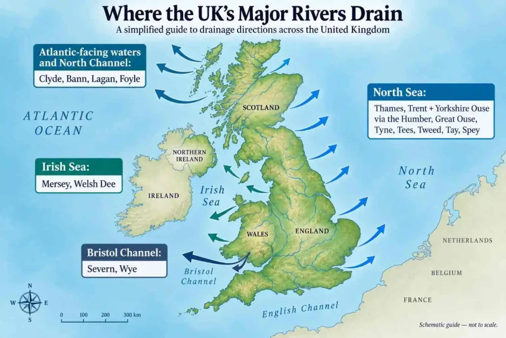
Look at a relief map and the drainage pattern becomes much easier to understand.
The Scottish Highlands send rivers toward both Atlantic-facing waters and the North Sea.
The Cambrian Mountains and Welsh uplands feed rivers such as the Severn, Wye and Tywi.
In northern England, the Pennines act as a major drainage divide. Rivers on their eastern side feed systems flowing toward the North Sea, while western catchments drain toward the Irish Sea.
The divide is not a simple straight line, but it helps explain why rivers with nearby headwaters can ultimately reach opposite coasts.
Where Do the UK’s Major Rivers Drain?
North Sea
Major North Sea-draining systems include:
- Thames via the Thames Estuary
- Trent and Yorkshire Ouse via the Humber Estuary
- Great Ouse via The Wash
- Tyne
- Tees
- Tweed
- Tay via the Firth of Tay
- Spey via the Moray Firth
Bristol Channel
The Severn reaches the Severn Estuary, which opens into the Bristol Channel.
The Wye also reaches the Severn estuarine system.
Irish Sea and Connected Waters
The Mersey enters the Irish Sea through the Mersey Estuary.
The Welsh Dee reaches the Dee Estuary, which also opens toward the Irish Sea.
Atlantic-Facing Waters and the North Channel
The Clyde reaches the Firth of Clyde.
The Bann reaches the Atlantic on Northern Ireland’s north coast, while the Foyle system reaches the sea through Lough Foyle. The Lagan reaches Belfast Lough and then the North Channel.
Using the immediate receiving water is more useful than saying simply that every UK river eventually connects with the Atlantic.
Rivers That Cross UK Country Boundaries
Internal UK boundaries do not match drainage divides.
The Severn rises in Wales and flows into England.
The Wye moves between Wales and England and also follows the boundary in places.
The Welsh Dee rises in Wales and continues into England.
The Tweed rises in Scotland, has a complicated relationship with the Scotland–England boundary, and reaches the sea in England.
A river can therefore cross a boundary, follow a boundary, or do both at different points. Those descriptions are not interchangeable.
Northern Ireland’s Cross-Border River Systems
Northern Ireland also has drainage systems that cross an international, not merely internal UK, boundary.
Official cross-border river-basin planning has long treated the Foyle and Erne basins within the North Western International River Basin District. The Neagh Bann district also contains waters extending across the border.
This is physical geography overriding political geography in the clearest possible way: rainfall follows slopes and catchments, not jurisdiction lines.
When a River Becomes an Estuary
UK river geography is full of names that change near the coast.
Useful examples include:
Severn → Severn Estuary → Bristol Channel
Thames → Thames Estuary → North Sea
Trent + Yorkshire Ouse → Humber Estuary → North Sea
Tay → Firth of Tay → North Sea
Clyde → Clyde Estuary / Firth of Clyde
The transition is not always a single sharp point. Tides can penetrate far upstream, and official water-body boundaries may use specific hydrological definitions.
That is why river length, estuary length and navigable length should never be mixed casually.
Why Do So Many UK Rivers Share the Same Name?
Several completely different UK rivers share names such as Avon, Dee, Ouse and Esk.
The best-known example is Avon. The name comes from an old Brittonic word meaning river, related to modern Welsh afon. That linguistic history helps explain why unrelated rivers in different parts of Britain ended up with the same name.
So “River Avon” is not precise enough in a UK-wide article. It may refer to the Bristol Avon, Warwickshire Avon, Hampshire Avon or another river.
The same caution applies to:
- Great Ouse vs Yorkshire Ouse vs Sussex Ouse
- Welsh Dee vs Scottish Dee
- several rivers named Esk
A map or data table should always identify which river is meant.
What Rivers Flow Through the UK’s Major Cities?
| City | River | Geographic Qualification |
|---|---|---|
| London | Thames | Tidal through central London |
| Glasgow | Clyde | Lower river; estuarine transition lies farther west |
| Belfast | Lagan | Reaches Belfast Lough |
| Cardiff | Taff | Flows through Cardiff toward Cardiff Bay |
| Newcastle upon Tyne | Tyne | Main river through the urban area |
| York | Yorkshire Ouse | Not the Great Ouse |
| Bristol | Bristol Avon | Specify which Avon |
| Perth | Tay | Main River Tay |
| Derry/Londonderry | Foyle | Lower river opens toward Lough Foyle |
| Edinburgh | Water of Leith | Edinburgh lies south of the Firth of Forth; the River Forth does not run through the city centre |
| Nottingham | Trent | River runs along the southern side of the urban area rather than through the central core |
| Liverpool | Mersey Estuary | City fronts the broad tidal estuary |
Two mistakes are especially easy to make.
Edinburgh is not simply a city “on the River Forth.” The city lies south of the Firth of Forth, while the Water of Leith flows through parts of Edinburgh.
Manchester city centre is not on the River Mersey. The Irwell is the central urban river, while the wider drainage ultimately belongs to the Mersey system.
The Bottom Line
The Severn is the UK’s longest river, while the Thames holds the more specific title of longest river entirely within England. Scotland’s Tay, Wales’s Tywi and Northern Ireland’s Bann each require their own definitions rather than being forced into one simplistic national ranking.
The wider map matters just as much as length. Uplands divide east- and west-flowing catchments, estuaries change the names and character of lower rivers, and several waterways cross the internal borders of the UK or the international boundary on the island of Ireland.
Understanding those relationships gives a much clearer picture of UK river geography than memorising a list of names.
Frequently Asked Questions
Major UK rivers include the Severn, Thames, Trent, Great Ouse, Wye, Tay, Clyde, Spey, Tweed, Tywi and Bann. The four UK countries have different river patterns, so a useful national list should include Scotland, Wales and Northern Ireland rather than focusing only on England.
The River Severn is the UK’s longest river at about 354 km (220 miles). It rises in the Cambrian Mountains of Wales, flows into England and reaches the Severn Estuary.
Yes. The Severn is about 354 km long, while the Thames is about 346 km. The Severn crosses Wales and England, whereas the Thames remains entirely within England.
The River Thames is the longest river entirely within England at approximately 346 km (215 miles). The Severn is longer overall but begins in Wales.
The River Tay is Scotland’s longest river at roughly 188–190 km under commonly used Scottish source-to-estuary measurements. It also has the highest mean flow of any British watercourse, but flow and length are separate measurements.
The Afon Tywi / River Tywi is commonly identified as the longest river entirely within Wales. Natural Resources Wales publications give differing approximate lengths of 108 km and 120 km, so it is better to state the source convention than invent false precision.
The River Bann is Northern Ireland’s longest river. Upper and Lower Bann river sections are commonly given a combined length of about 129 km. A longer figure, about 159 km, results when the route across Lough Neagh is included.
The River Thames flows through London. The river is tidal through central London and eventually opens into the Thames Estuary before reaching the North Sea.
The River Lagan flows through Belfast and reaches Belfast Lough.
The UK is a relatively narrow island state with an indented coastline and many upland drainage divides close to the sea. Rivers therefore have less continental interior to cross before reaching coastal waters.